You are here: Home > Network List > UO - University of Oregon Regional Network Stations List
> Station DING Powers, OR, USA > Earthquake Result Viewer
DING Powers, OR, USA - Earthquake Result Viewer
| Earthquake location: |
Near Coast Of Central Chile |
| Earthquake latitude/longitude: |
-28.7/-71.6 |
| Earthquake time(UTC): |
2023/10/31 (304) 12:33:44 GMT |
| Earthquake Depth: |
41 km |
| Earthquake Magnitude: |
6.7 mww |
| Earthquake Catalog/Contributor: |
NEIC PDE/us |
|
| Network: |
UO University of Oregon Regional Network |
| Station: |
DING Powers, OR, USA |
| Lat/Lon: |
42.86 N/124.05 W |
| Elevation: |
100 m |
|
| Distance: |
86.0 deg |
| Az: |
324.227 deg |
| Baz: |
135.722 deg |
| Ray Param: |
0.04427401 |
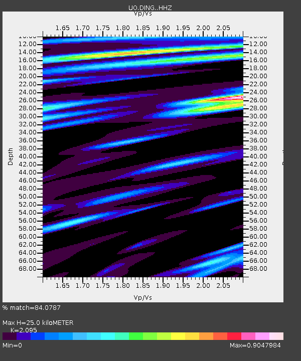
| Estimated Moho Depth: |
25.0 km |
| Estimated Crust Vp/Vs: |
2.10 |
| Assumed Crust Vp: |
6.048 km/s |
| Estimated Crust Vs: |
2.887 km/s |
| Estimated Crust Poisson's Ratio: |
0.35 |
|
| Radial Match: |
84.0787 % |
| Radial Bump: |
390 |
| Transverse Match: |
87.32123 % |
| Transverse Bump: |
400 |
| SOD ConfigId: |
31937991 |
| Insert Time: |
2023-11-14 12:59:48.871 +0000 |
| GWidth: |
2.5 |
| Max Bumps: |
400 |
| Tol: |
0.001 |
|

Signal To Noise
| Channel | StoN | STA | LTA |
| UO:DING: :HHZ:20231031T12:45:49.440023Z | 2.501518 | 8.065583E-7 | 3.2242755E-7 |
| UO:DING: :HHN:20231031T12:45:49.440023Z | 0.4364589 | 1.0542793E-7 | 2.4155295E-7 |
| UO:DING: :HHE:20231031T12:45:49.440023Z | 1.0371654 | 1.5501129E-7 | 1.4945668E-7 |
| Arrivals |
| Ps | 4.6 SECOND |
| PpPs | 13 SECOND |
| PsPs/PpSs | 17 SECOND |


