You are here: Home > Network List > UU - University of Utah Regional Network Stations List
> Station FPU Francis Peak, UT, USA > Earthquake Result Viewer
FPU Francis Peak, UT, USA - Earthquake Result Viewer
| Earthquake location: |
Near Coast Of Central Chile |
| Earthquake latitude/longitude: |
-28.7/-71.6 |
| Earthquake time(UTC): |
2023/10/31 (304) 12:33:44 GMT |
| Earthquake Depth: |
41 km |
| Earthquake Magnitude: |
6.7 mww |
| Earthquake Catalog/Contributor: |
NEIC PDE/us |
|
| Network: |
UU University of Utah Regional Network |
| Station: |
FPU Francis Peak, UT, USA |
| Lat/Lon: |
41.03 N/111.84 W |
| Elevation: |
2816 m |
|
| Distance: |
78.8 deg |
| Az: |
330.101 deg |
| Baz: |
144.652 deg |
| Ray Param: |
0.049328264 |
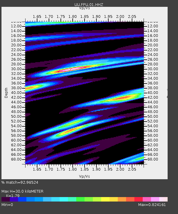
| Estimated Moho Depth: |
30.0 km |
| Estimated Crust Vp/Vs: |
1.79 |
| Assumed Crust Vp: |
6.155 km/s |
| Estimated Crust Vs: |
3.438 km/s |
| Estimated Crust Poisson's Ratio: |
0.27 |
|
| Radial Match: |
92.96524 % |
| Radial Bump: |
296 |
| Transverse Match: |
77.26441 % |
| Transverse Bump: |
400 |
| SOD ConfigId: |
31937991 |
| Insert Time: |
2023-11-14 13:03:03.543 +0000 |
| GWidth: |
2.5 |
| Max Bumps: |
400 |
| Tol: |
0.001 |
|

Signal To Noise
| Channel | StoN | STA | LTA |
| UU:FPU:01:HHZ:20231031T12:45:11.849997Z | 2.1464338 | 5.5874864E-7 | 2.603149E-7 |
| UU:FPU:01:HHN:20231031T12:45:11.849997Z | 1.2445941 | 3.6552677E-7 | 2.9369156E-7 |
| UU:FPU:01:HHE:20231031T12:45:11.849997Z | 1.3721712 | 3.5927235E-7 | 2.6182764E-7 |
| Arrivals |
| Ps | 4.0 SECOND |
| PpPs | 13 SECOND |
| PsPs/PpSs | 17 SECOND |


