You are here: Home > Network List > UW - Pacific Northwest Regional Seismic Network Stations List
> Station HOOD Mt Hood Meadows, OR CREST BB SMO > Earthquake Result Viewer
HOOD Mt Hood Meadows, OR CREST BB SMO - Earthquake Result Viewer

| Earthquake location: |
Near Coast Of Central Chile |
| Earthquake latitude/longitude: |
-28.7/-71.6 |
| Earthquake time(UTC): |
2023/10/31 (304) 12:33:44 GMT |
| Earthquake Depth: |
41 km |
| Earthquake Magnitude: |
6.7 mww |
| Earthquake Catalog/Contributor: |
NEIC PDE/us |
|
| Network: |
UW Pacific Northwest Regional Seismic Network |
| Station: |
HOOD Mt Hood Meadows, OR CREST BB SMO |
| Lat/Lon: |
45.32 N/121.65 W |
| Elevation: |
1520 m |
|
| Distance: |
86.6 deg |
| Az: |
327.179 deg |
| Baz: |
137.575 deg |
| Ray Param: |
0.043840792 |
| Estimated Moho Depth: |
31.0 km |
| Estimated Crust Vp/Vs: |
1.98 |
| Assumed Crust Vp: |
6.597 km/s |
| Estimated Crust Vs: |
3.341 km/s |
| Estimated Crust Poisson's Ratio: |
0.33 |
|
| Radial Match: |
88.84146 % |
| Radial Bump: |
400 |
| Transverse Match: |
80.17006 % |
| Transverse Bump: |
400 |
| SOD ConfigId: |
31937991 |
| Insert Time: |
2023-11-14 13:04:21.039 +0000 |
| GWidth: |
2.5 |
| Max Bumps: |
400 |
| Tol: |
0.001 |
|
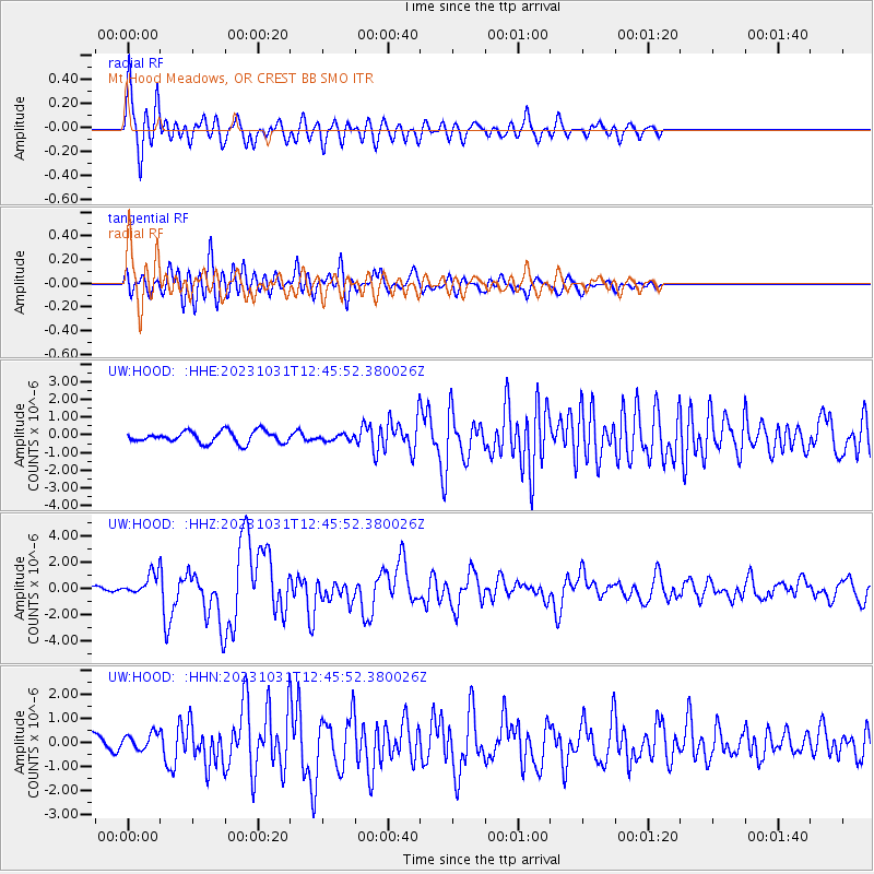
Signal To Noise
| Channel | StoN | STA | LTA |
| UW:HOOD: :HHZ:20231031T12:45:52.380026Z | 2.3391562 | 8.12782E-7 | 3.4746805E-7 |
| UW:HOOD: :HHN:20231031T12:45:52.380026Z | 0.9812977 | 3.436318E-7 | 3.5018098E-7 |
| UW:HOOD: :HHE:20231031T12:45:52.380026Z | 0.50683635 | 1.6726666E-7 | 3.3002104E-7 |
| Arrivals |
| Ps | 4.7 SECOND |
| PpPs | 14 SECOND |
| PsPs/PpSs | 18 SECOND |


