You are here: Home > Network List > UW - Pacific Northwest Regional Seismic Network Stations List
> Station VFP Flag Point, OR, USA > Earthquake Result Viewer
VFP Flag Point, OR, USA - Earthquake Result Viewer
| Earthquake location: |
Near Coast Of Central Chile |
| Earthquake latitude/longitude: |
-28.7/-71.6 |
| Earthquake time(UTC): |
2023/10/31 (304) 12:33:44 GMT |
| Earthquake Depth: |
41 km |
| Earthquake Magnitude: |
6.7 mww |
| Earthquake Catalog/Contributor: |
NEIC PDE/us |
|
| Network: |
UW Pacific Northwest Regional Seismic Network |
| Station: |
VFP Flag Point, OR, USA |
| Lat/Lon: |
45.32 N/121.47 W |
| Elevation: |
1722 m |
|
| Distance: |
86.6 deg |
| Az: |
327.274 deg |
| Baz: |
137.713 deg |
| Ray Param: |
0.043907266 |
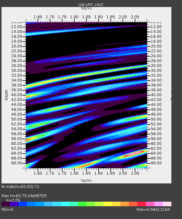
| Estimated Moho Depth: |
63.75 km |
| Estimated Crust Vp/Vs: |
2.05 |
| Assumed Crust Vp: |
6.597 km/s |
| Estimated Crust Vs: |
3.218 km/s |
| Estimated Crust Poisson's Ratio: |
0.34 |
|
| Radial Match: |
83.00173 % |
| Radial Bump: |
400 |
| Transverse Match: |
88.11249 % |
| Transverse Bump: |
400 |
| SOD ConfigId: |
31937991 |
| Insert Time: |
2023-11-14 13:06:08.353 +0000 |
| GWidth: |
2.5 |
| Max Bumps: |
400 |
| Tol: |
0.001 |
|

Signal To Noise
| Channel | StoN | STA | LTA |
| UW:VFP: :HHZ:20231031T12:45:51.930014Z | 2.2614987 | 8.414914E-7 | 3.7209455E-7 |
| UW:VFP: :HHN:20231031T12:45:51.930014Z | 0.71617633 | 3.205997E-7 | 4.4765468E-7 |
| UW:VFP: :HHE:20231031T12:45:51.930014Z | 0.6151811 | 3.5735496E-7 | 5.808939E-7 |
| Arrivals |
| Ps | 10 SECOND |
| PpPs | 29 SECOND |
| PsPs/PpSs | 39 SECOND |


