You are here: Home > Network List > WY - Yellowstone Wyoming Seismic Network Stations List
> Station YMV Mammoth Vault, YNP, WY, USA > Earthquake Result Viewer
YMV Mammoth Vault, YNP, WY, USA - Earthquake Result Viewer
| Earthquake location: |
Near Coast Of Central Chile |
| Earthquake latitude/longitude: |
-28.7/-71.6 |
| Earthquake time(UTC): |
2023/10/31 (304) 12:33:44 GMT |
| Earthquake Depth: |
41 km |
| Earthquake Magnitude: |
6.7 mww |
| Earthquake Catalog/Contributor: |
NEIC PDE/us |
|
| Network: |
WY Yellowstone Wyoming Seismic Network |
| Station: |
YMV Mammoth Vault, YNP, WY, USA |
| Lat/Lon: |
44.97 N/110.69 W |
| Elevation: |
1829 m |
|
| Distance: |
81.6 deg |
| Az: |
333.083 deg |
| Baz: |
145.941 deg |
| Ray Param: |
0.047433704 |
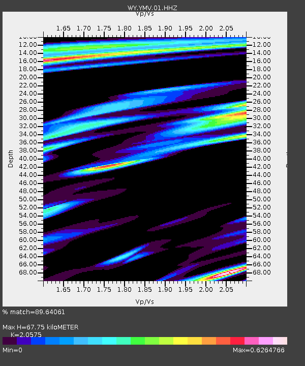
| Estimated Moho Depth: |
67.75 km |
| Estimated Crust Vp/Vs: |
2.06 |
| Assumed Crust Vp: |
6.35 km/s |
| Estimated Crust Vs: |
3.086 km/s |
| Estimated Crust Poisson's Ratio: |
0.35 |
|
| Radial Match: |
89.64061 % |
| Radial Bump: |
400 |
| Transverse Match: |
86.82972 % |
| Transverse Bump: |
400 |
| SOD ConfigId: |
31937991 |
| Insert Time: |
2023-11-14 13:07:41.209 +0000 |
| GWidth: |
2.5 |
| Max Bumps: |
400 |
| Tol: |
0.001 |
|

Signal To Noise
| Channel | StoN | STA | LTA |
| WY:YMV:01:HHZ:20231031T12:45:26.680014Z | 2.5611656 | 6.033535E-7 | 2.3557769E-7 |
| WY:YMV:01:HHN:20231031T12:45:26.680014Z | 1.3601593 | 3.3213246E-7 | 2.4418645E-7 |
| WY:YMV:01:HHE:20231031T12:45:26.680014Z | 1.2333373 | 3.7033743E-7 | 3.0027263E-7 |
| Arrivals |
| Ps | 12 SECOND |
| PpPs | 32 SECOND |
| PsPs/PpSs | 43 SECOND |


