You are here: Home > Network List > CI - Caltech Regional Seismic Network Stations List
> Station MPP McPhearson Peak > Earthquake Result Viewer
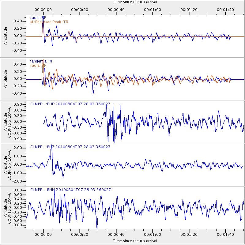
MPP McPhearson Peak - Earthquake Result Viewer
*The percent match for this event was below the threshold and hence no stack was calculated.
| Earthquake location: |
Eastern New Guinea Reg., P.N.G. |
| Earthquake latitude/longitude: |
-5.5/146.8 |
| Earthquake time(UTC): |
2010/08/04 (216) 07:15:34 GMT |
| Earthquake Depth: |
226 km |
| Earthquake Magnitude: |
6.1 MB, 6.5 MW, 6.4 MW |
| Earthquake Catalog/Contributor: |
WHDF/NEIC |
|
| Network: |
CI Caltech Regional Seismic Network |
| Station: |
MPP McPhearson Peak |
| Lat/Lon: |
34.89 N/119.81 W |
| Elevation: |
1739 m |
|
| Distance: |
95.9 deg |
| Az: |
55.585 deg |
| Baz: |
267.416 deg |
| Ray Param: |
$rayparam |
*The percent match for this event was below the threshold and hence was not used in the summary stack. |
|
| Radial Match: |
71.7225 % |
| Radial Bump: |
400 |
| Transverse Match: |
64.12915 % |
| Transverse Bump: |
400 |
| SOD ConfigId: |
319893 |
| Insert Time: |
2011-01-05 16:04:00.937 +0000 |
| GWidth: |
2.5 |
| Max Bumps: |
400 |
| Tol: |
0.001 |
|
Signal To Noise
| Channel | StoN | STA | LTA |
| CI:MPP: :BHZ:20100804T07:28:03.36002Z | 5.3457613 | 9.2506E-7 | 1.7304552E-7 |
| CI:MPP: :BHN:20100804T07:28:03.36002Z | 1.1460118 | 2.3116246E-7 | 2.0171036E-7 |
| CI:MPP: :BHE:20100804T07:28:03.36002Z | 1.4582314 | 3.461364E-7 | 2.3736725E-7 |
| Arrivals |
| Ps | |
| PpPs | |
| PsPs/PpSs | |


