You are here: Home > Network List > G - GEOSCOPE Stations List
> Station KIP Kipapa - Hawaii, USA > Earthquake Result Viewer
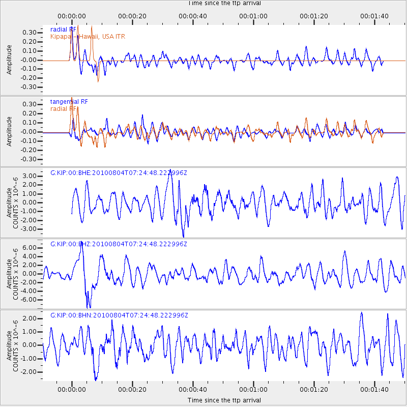
KIP Kipapa - Hawaii, USA - Earthquake Result Viewer
*The percent match for this event was below the threshold and hence no stack was calculated.
| Earthquake location: |
Eastern New Guinea Reg., P.N.G. |
| Earthquake latitude/longitude: |
-5.5/146.8 |
| Earthquake time(UTC): |
2010/08/04 (216) 07:15:34 GMT |
| Earthquake Depth: |
226 km |
| Earthquake Magnitude: |
6.1 MB, 6.5 MW, 6.4 MW |
| Earthquake Catalog/Contributor: |
WHDF/NEIC |
|
| Network: |
G GEOSCOPE |
| Station: |
KIP Kipapa - Hawaii, USA |
| Lat/Lon: |
21.42 N/158.01 W |
| Elevation: |
70 m |
|
| Distance: |
60.3 deg |
| Az: |
61.684 deg |
| Baz: |
250.145 deg |
| Ray Param: |
$rayparam |
*The percent match for this event was below the threshold and hence was not used in the summary stack. |
|
| Radial Match: |
60.2359 % |
| Radial Bump: |
400 |
| Transverse Match: |
59.41927 % |
| Transverse Bump: |
400 |
| SOD ConfigId: |
319893 |
| Insert Time: |
2011-01-05 16:05:40.382 +0000 |
| GWidth: |
2.5 |
| Max Bumps: |
400 |
| Tol: |
0.001 |
|
Signal To Noise
| Channel | StoN | STA | LTA |
| G:KIP:00:BHZ:20100804T07:24:48.222996Z | 2.7095132 | 3.6946906E-6 | 1.3635994E-6 |
| G:KIP:00:BHN:20100804T07:24:48.222996Z | 0.92589635 | 6.3174696E-7 | 6.8230855E-7 |
| G:KIP:00:BHE:20100804T07:24:48.222996Z | 2.0959113 | 2.0781479E-6 | 9.915246E-7 |
| Arrivals |
| Ps | |
| PpPs | |
| PsPs/PpSs | |


