You are here: Home > Network List > PS - Pacific21 Stations List
> Station INU Inuyama, Japan > Earthquake Result Viewer
INU Inuyama, Japan - Earthquake Result Viewer
| Earthquake location: |
Timor Region |
| Earthquake latitude/longitude: |
-10.0/123.7 |
| Earthquake time(UTC): |
2023/11/01 (305) 21:04:45 GMT |
| Earthquake Depth: |
28 km |
| Earthquake Magnitude: |
6.0 mww |
| Earthquake Catalog/Contributor: |
NEIC PDE/us |
|
| Network: |
PS Pacific21 |
| Station: |
INU Inuyama, Japan |
| Lat/Lon: |
35.35 N/137.03 E |
| Elevation: |
132 m |
|
| Distance: |
46.8 deg |
| Az: |
14.958 deg |
| Baz: |
198.12 deg |
| Ray Param: |
0.07034676 |
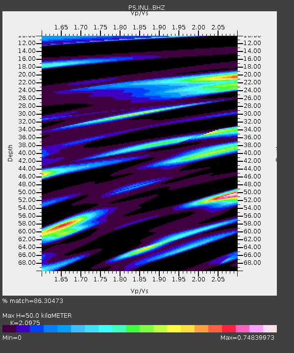
| Estimated Moho Depth: |
50.0 km |
| Estimated Crust Vp/Vs: |
2.10 |
| Assumed Crust Vp: |
6.461 km/s |
| Estimated Crust Vs: |
3.081 km/s |
| Estimated Crust Poisson's Ratio: |
0.35 |
|
| Radial Match: |
86.30473 % |
| Radial Bump: |
400 |
| Transverse Match: |
71.12899 % |
| Transverse Bump: |
400 |
| SOD ConfigId: |
31937991 |
| Insert Time: |
2023-11-15 21:13:55.778 +0000 |
| GWidth: |
2.5 |
| Max Bumps: |
400 |
| Tol: |
0.001 |
|

Signal To Noise
| Channel | StoN | STA | LTA |
| PS:INU: :BHZ:20231101T21:12:42.361002Z | 3.3197465 | 4.6282815E-7 | 1.3941671E-7 |
| PS:INU: :BHN:20231101T21:12:42.361002Z | 1.333874 | 2.5621634E-7 | 1.9208437E-7 |
| PS:INU: :BHE:20231101T21:12:42.361002Z | 0.70476705 | 1.3742137E-7 | 1.9498836E-7 |
| Arrivals |
| Ps | 9.0 SECOND |
| PpPs | 23 SECOND |
| PsPs/PpSs | 32 SECOND |


