You are here: Home > Network List > IM - International Miscellaneous Stations Stations List
> Station MK31 Makanchi Array Site 31, Kazakhstan > Earthquake Result Viewer
MK31 Makanchi Array Site 31, Kazakhstan - Earthquake Result Viewer
| Earthquake location: |
Eastern New Guinea Reg., P.N.G. |
| Earthquake latitude/longitude: |
-5.5/146.8 |
| Earthquake time(UTC): |
2010/08/04 (216) 07:15:34 GMT |
| Earthquake Depth: |
226 km |
| Earthquake Magnitude: |
6.1 MB, 6.5 MW, 6.4 MW |
| Earthquake Catalog/Contributor: |
WHDF/NEIC |
|
| Network: |
IM International Miscellaneous Stations |
| Station: |
MK31 Makanchi Array Site 31, Kazakhstan |
| Lat/Lon: |
46.79 N/82.29 E |
| Elevation: |
618 m |
|
| Distance: |
77.0 deg |
| Az: |
320.463 deg |
| Baz: |
112.733 deg |
| Ray Param: |
0.05003196 |
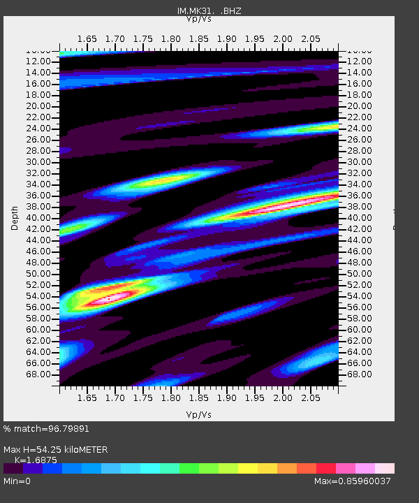
| Estimated Moho Depth: |
54.25 km |
| Estimated Crust Vp/Vs: |
1.69 |
| Assumed Crust Vp: |
6.688 km/s |
| Estimated Crust Vs: |
3.963 km/s |
| Estimated Crust Poisson's Ratio: |
0.23 |
|
| Radial Match: |
96.79891 % |
| Radial Bump: |
400 |
| Transverse Match: |
87.06983 % |
| Transverse Bump: |
400 |
| SOD ConfigId: |
319893 |
| Insert Time: |
2011-01-05 16:08:36.493 +0000 |
| GWidth: |
2.5 |
| Max Bumps: |
400 |
| Tol: |
0.001 |
|

Signal To Noise
| Channel | StoN | STA | LTA |
| IM:MK31: :BHZ:20100804T07:26:30.72501Z | 51.849022 | 9.173772E-8 | 1.769324E-9 |
| IM:MK31: :BHN:20100804T07:26:30.72501Z | 11.33826 | 1.6104213E-8 | 1.4203426E-9 |
| IM:MK31: :BHE:20100804T07:26:30.72501Z | 21.364475 | 2.9669476E-8 | 1.3887295E-9 |
| Arrivals |
| Ps | 5.8 SECOND |
| PpPs | 21 SECOND |
| PsPs/PpSs | 27 SECOND |


