You are here: Home > Network List > KN - Kyrgyz Seismic Telemetry Network Stations List
> Station KZA KN.KZA > Earthquake Result Viewer
KZA KN.KZA - Earthquake Result Viewer

| Earthquake location: |
Eastern New Guinea Reg., P.N.G. |
| Earthquake latitude/longitude: |
-5.5/146.8 |
| Earthquake time(UTC): |
2010/08/04 (216) 07:15:34 GMT |
| Earthquake Depth: |
226 km |
| Earthquake Magnitude: |
6.1 MB, 6.5 MW, 6.4 MW |
| Earthquake Catalog/Contributor: |
WHDF/NEIC |
|
| Network: |
KN Kyrgyz Seismic Telemetry Network |
| Station: |
KZA KN.KZA |
| Lat/Lon: |
42.08 N/75.25 E |
| Elevation: |
3520 m |
|
| Distance: |
80.2 deg |
| Az: |
314.21 deg |
| Baz: |
106.573 deg |
| Ray Param: |
0.04790107 |
| Estimated Moho Depth: |
19.25 km |
| Estimated Crust Vp/Vs: |
1.60 |
| Assumed Crust Vp: |
6.306 km/s |
| Estimated Crust Vs: |
3.941 km/s |
| Estimated Crust Poisson's Ratio: |
0.18 |
|
| Radial Match: |
94.312874 % |
| Radial Bump: |
400 |
| Transverse Match: |
87.67311 % |
| Transverse Bump: |
400 |
| SOD ConfigId: |
319893 |
| Insert Time: |
2011-01-05 16:10:24.835 +0000 |
| GWidth: |
2.5 |
| Max Bumps: |
400 |
| Tol: |
0.001 |
|
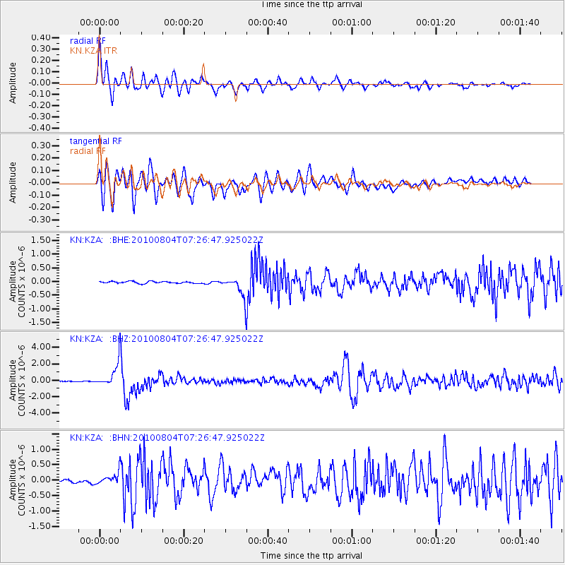
Signal To Noise
| Channel | StoN | STA | LTA |
| KN:KZA: :BHZ:20100804T07:26:47.925022Z | 33.606564 | 1.4978398E-6 | 4.4569855E-8 |
| KN:KZA: :BHN:20100804T07:26:47.925022Z | 3.408173 | 1.948561E-7 | 5.717318E-8 |
| KN:KZA: :BHE:20100804T07:26:47.925022Z | 11.245242 | 3.968128E-7 | 3.5287172E-8 |
| Arrivals |
| Ps | 1.9 SECOND |
| PpPs | 7.7 SECOND |
| PsPs/PpSs | 9.6 SECOND |


