You are here: Home > Network List > UW - Pacific Northwest Regional Seismic Network Stations List
> Station MRBL Marblemount, WA, USA > Earthquake Result Viewer
MRBL Marblemount, WA, USA - Earthquake Result Viewer
| Earthquake location: |
Eastern New Guinea Reg., P.N.G. |
| Earthquake latitude/longitude: |
-5.5/146.8 |
| Earthquake time(UTC): |
2010/08/04 (216) 07:15:34 GMT |
| Earthquake Depth: |
226 km |
| Earthquake Magnitude: |
6.1 MB, 6.5 MW, 6.4 MW |
| Earthquake Catalog/Contributor: |
WHDF/NEIC |
|
| Network: |
UW Pacific Northwest Regional Seismic Network |
| Station: |
MRBL Marblemount, WA, USA |
| Lat/Lon: |
48.52 N/121.48 W |
| Elevation: |
75 m |
|
| Distance: |
95.2 deg |
| Az: |
41.862 deg |
| Baz: |
267.632 deg |
| Ray Param: |
0.040661283 |
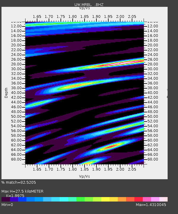
| Estimated Moho Depth: |
27.5 km |
| Estimated Crust Vp/Vs: |
2.00 |
| Assumed Crust Vp: |
6.566 km/s |
| Estimated Crust Vs: |
3.287 km/s |
| Estimated Crust Poisson's Ratio: |
0.33 |
|
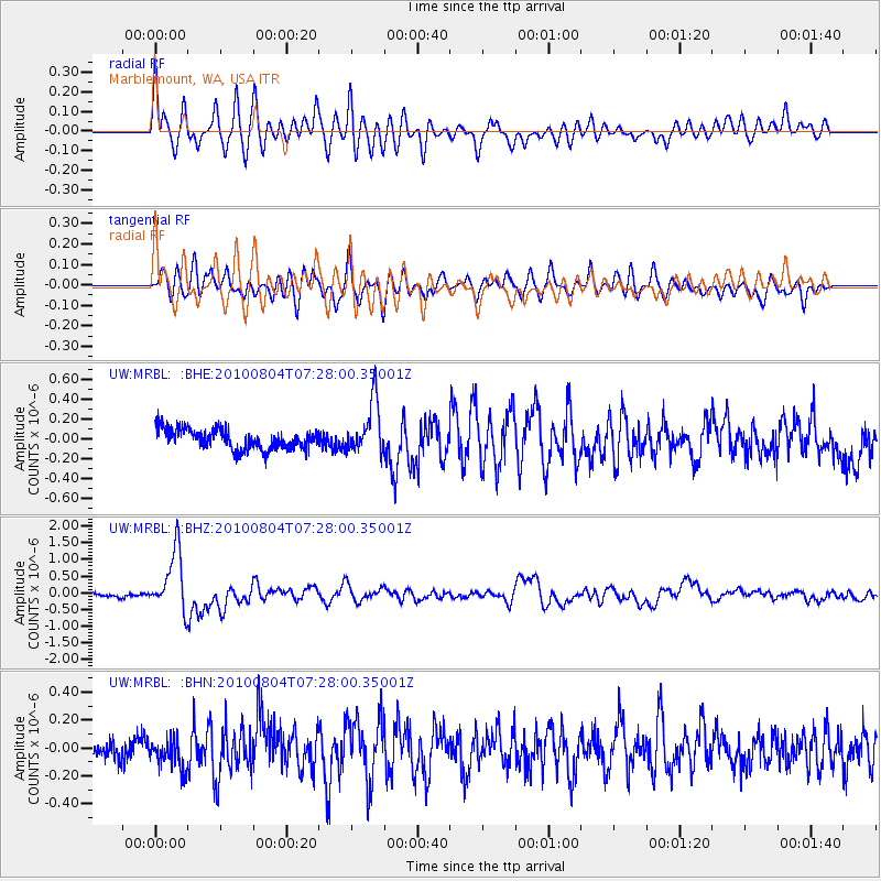
| Radial Match: |
82.5205 % |
| Radial Bump: |
400 |
| Transverse Match: |
78.833496 % |
| Transverse Bump: |
400 |
| SOD ConfigId: |
319893 |
| Insert Time: |
2011-01-05 16:18:16.270 +0000 |
| GWidth: |
2.5 |
| Max Bumps: |
400 |
| Tol: |
0.001 |
|
Signal To Noise
| Channel | StoN | STA | LTA |
| UW:MRBL: :BHZ:20100804T07:28:00.35001Z | 9.188968 | 9.0332185E-7 | 9.8305044E-8 |
| UW:MRBL: :BHN:20100804T07:28:00.35001Z | 1.2130141 | 1.120055E-7 | 9.233651E-8 |
| UW:MRBL: :BHE:20100804T07:28:00.35001Z | 2.598537 | 2.6140023E-7 | 1.00595166E-7 |
| Arrivals |
| Ps | 4.3 SECOND |
| PpPs | 12 SECOND |
| PsPs/PpSs | 17 SECOND |


