You are here: Home > Network List > AV - Alaska Volcano Observatory Stations List
> Station SPNN North Nagishlamina, Mount Spurr, Alaska > Earthquake Result Viewer
SPNN North Nagishlamina, Mount Spurr, Alaska - Earthquake Result Viewer
| Earthquake location: |
Nepal |
| Earthquake latitude/longitude: |
28.9/82.2 |
| Earthquake time(UTC): |
2023/11/03 (307) 18:02:54 GMT |
| Earthquake Depth: |
18 km |
| Earthquake Magnitude: |
5.6 Mww |
| Earthquake Catalog/Contributor: |
NEIC PDE/us |
|
| Network: |
AV Alaska Volcano Observatory |
| Station: |
SPNN North Nagishlamina, Mount Spurr, Alaska |
| Lat/Lon: |
61.37 N/152.70 W |
| Elevation: |
1666 m |
|
| Distance: |
79.7 deg |
| Az: |
23.609 deg |
| Baz: |
313.188 deg |
| Ray Param: |
0.048746213 |
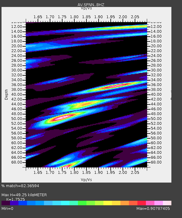
| Estimated Moho Depth: |
49.25 km |
| Estimated Crust Vp/Vs: |
1.75 |
| Assumed Crust Vp: |
6.566 km/s |
| Estimated Crust Vs: |
3.747 km/s |
| Estimated Crust Poisson's Ratio: |
0.26 |
|
| Radial Match: |
82.36594 % |
| Radial Bump: |
400 |
| Transverse Match: |
82.57215 % |
| Transverse Bump: |
400 |
| SOD ConfigId: |
31937991 |
| Insert Time: |
2023-11-17 18:12:02.248 +0000 |
| GWidth: |
2.5 |
| Max Bumps: |
400 |
| Tol: |
0.001 |
|

Signal To Noise
| Channel | StoN | STA | LTA |
| AV:SPNN: :BHZ:20231103T18:14:29.779027Z | 11.670656 | 1.3752011E-6 | 1.1783409E-7 |
| AV:SPNN: :BHN:20231103T18:14:29.779027Z | 3.877563 | 4.7467327E-7 | 1.2241536E-7 |
| AV:SPNN: :BHE:20231103T18:14:29.779027Z | 3.3957844 | 3.2099177E-7 | 9.452655E-8 |
| Arrivals |
| Ps | 5.8 SECOND |
| PpPs | 20 SECOND |
| PsPs/PpSs | 26 SECOND |


