You are here: Home > Network List > PS - Pacific21 Stations List
> Station INU Inuyama, Japan > Earthquake Result Viewer
INU Inuyama, Japan - Earthquake Result Viewer
| Earthquake location: |
Nepal |
| Earthquake latitude/longitude: |
28.9/82.2 |
| Earthquake time(UTC): |
2023/11/03 (307) 18:02:54 GMT |
| Earthquake Depth: |
18 km |
| Earthquake Magnitude: |
5.6 Mww |
| Earthquake Catalog/Contributor: |
NEIC PDE/us |
|
| Network: |
PS Pacific21 |
| Station: |
INU Inuyama, Japan |
| Lat/Lon: |
35.35 N/137.03 E |
| Elevation: |
132 m |
|
| Distance: |
46.4 deg |
| Az: |
67.355 deg |
| Baz: |
278.097 deg |
| Ray Param: |
0.07066332 |
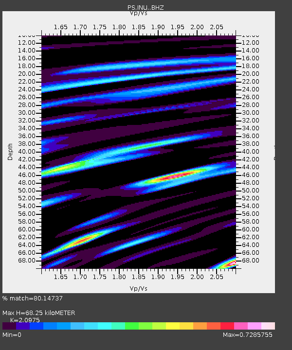
| Estimated Moho Depth: |
68.25 km |
| Estimated Crust Vp/Vs: |
2.10 |
| Assumed Crust Vp: |
6.461 km/s |
| Estimated Crust Vs: |
3.081 km/s |
| Estimated Crust Poisson's Ratio: |
0.35 |
|
| Radial Match: |
80.14737 % |
| Radial Bump: |
400 |
| Transverse Match: |
64.93442 % |
| Transverse Bump: |
400 |
| SOD ConfigId: |
31937991 |
| Insert Time: |
2023-11-17 18:18:43.843 +0000 |
| GWidth: |
2.5 |
| Max Bumps: |
400 |
| Tol: |
0.001 |
|

Signal To Noise
| Channel | StoN | STA | LTA |
| PS:INU: :BHZ:20231103T18:10:48.860998Z | 9.726511 | 1.0648218E-6 | 1.0947625E-7 |
| PS:INU: :BHN:20231103T18:10:48.860998Z | 1.4636068 | 1.9652957E-7 | 1.3427757E-7 |
| PS:INU: :BHE:20231103T18:10:48.860998Z | 6.9549546 | 5.3668987E-7 | 7.7166554E-8 |
| Arrivals |
| Ps | 12 SECOND |
| PpPs | 31 SECOND |
| PsPs/PpSs | 43 SECOND |


