You are here: Home > Network List > TA - USArray Transportable Network (new EarthScope stations) Stations List
> Station T27A Campo, CO, USA > Earthquake Result Viewer
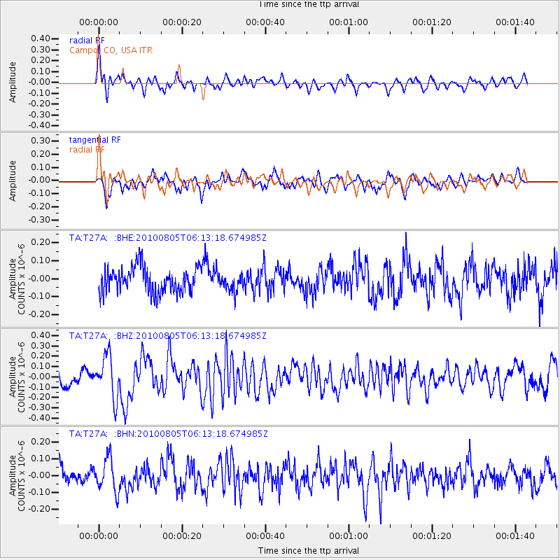
T27A Campo, CO, USA - Earthquake Result Viewer
*The percent match for this event was below the threshold and hence no stack was calculated.
| Earthquake location: |
Near Coast Of Central Chile |
| Earthquake latitude/longitude: |
-37.4/-73.3 |
| Earthquake time(UTC): |
2010/08/05 (217) 06:01:47 GMT |
| Earthquake Depth: |
18 km |
| Earthquake Magnitude: |
5.5 MS, 5.4 MB, 5.9 MW, 5.8 MW |
| Earthquake Catalog/Contributor: |
WHDF/NEIC |
|
| Network: |
TA USArray Transportable Network (new EarthScope stations) |
| Station: |
T27A Campo, CO, USA |
| Lat/Lon: |
37.06 N/102.72 W |
| Elevation: |
1366 m |
|
| Distance: |
79.0 deg |
| Az: |
336.386 deg |
| Baz: |
156.512 deg |
| Ray Param: |
$rayparam |
*The percent match for this event was below the threshold and hence was not used in the summary stack. |
|
| Radial Match: |
60.350266 % |
| Radial Bump: |
385 |
| Transverse Match: |
69.28987 % |
| Transverse Bump: |
400 |
| SOD ConfigId: |
319893 |
| Insert Time: |
2011-01-05 17:53:11.458 +0000 |
| GWidth: |
2.5 |
| Max Bumps: |
400 |
| Tol: |
0.001 |
|
Signal To Noise
| Channel | StoN | STA | LTA |
| TA:T27A: :BHZ:20100805T06:13:18.674985Z | 2.687849 | 2.1158957E-7 | 7.872078E-8 |
| TA:T27A: :BHN:20100805T06:13:18.674985Z | 1.8409283 | 1.0245285E-7 | 5.565282E-8 |
| TA:T27A: :BHE:20100805T06:13:18.674985Z | 0.69520116 | 4.8120175E-8 | 6.921763E-8 |
| Arrivals |
| Ps | |
| PpPs | |
| PsPs/PpSs | |


