You are here: Home > Network List > TA - USArray Transportable Network (new EarthScope stations) Stations List
> Station 631A Perdido Creek Ranch, Del Rio, TX, USA > Earthquake Result Viewer
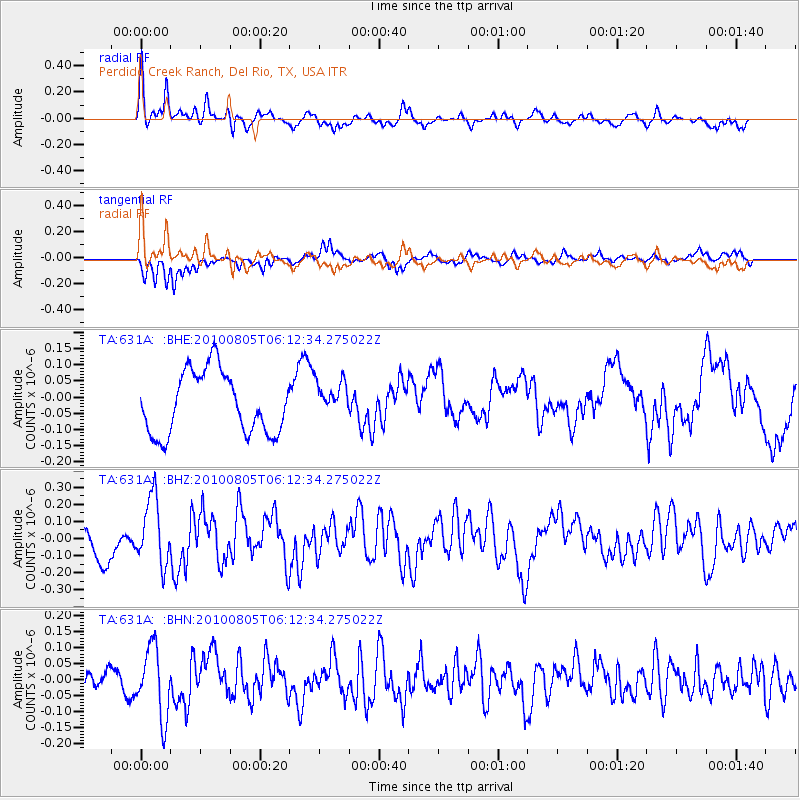
631A Perdido Creek Ranch, Del Rio, TX, USA - Earthquake Result Viewer
*The percent match for this event was below the threshold and hence no stack was calculated.
| Earthquake location: |
Near Coast Of Central Chile |
| Earthquake latitude/longitude: |
-37.4/-73.3 |
| Earthquake time(UTC): |
2010/08/05 (217) 06:01:47 GMT |
| Earthquake Depth: |
18 km |
| Earthquake Magnitude: |
5.5 MS, 5.4 MB, 5.9 MW, 5.8 MW |
| Earthquake Catalog/Contributor: |
WHDF/NEIC |
|
| Network: |
TA USArray Transportable Network (new EarthScope stations) |
| Station: |
631A Perdido Creek Ranch, Del Rio, TX, USA |
| Lat/Lon: |
29.41 N/100.58 W |
| Elevation: |
344 m |
|
| Distance: |
71.3 deg |
| Az: |
335.006 deg |
| Baz: |
157.33 deg |
| Ray Param: |
$rayparam |
*The percent match for this event was below the threshold and hence was not used in the summary stack. |
|
| Radial Match: |
74.62823 % |
| Radial Bump: |
400 |
| Transverse Match: |
78.77285 % |
| Transverse Bump: |
357 |
| SOD ConfigId: |
319893 |
| Insert Time: |
2011-01-05 17:55:01.960 +0000 |
| GWidth: |
2.5 |
| Max Bumps: |
400 |
| Tol: |
0.001 |
|
Signal To Noise
| Channel | StoN | STA | LTA |
| TA:631A: :BHZ:20100805T06:12:34.275022Z | 2.0288606 | 1.9447087E-7 | 9.585226E-8 |
| TA:631A: :BHN:20100805T06:12:34.275022Z | 2.6928425 | 1.0800639E-7 | 4.010869E-8 |
| TA:631A: :BHE:20100805T06:12:34.275022Z | 0.5753985 | 5.5148234E-8 | 9.5843546E-8 |
| Arrivals |
| Ps | |
| PpPs | |
| PsPs/PpSs | |


