You are here: Home > Network List > AK - Alaska Regional Network Stations List
> Station ANM Anvil Mountian > Earthquake Result Viewer
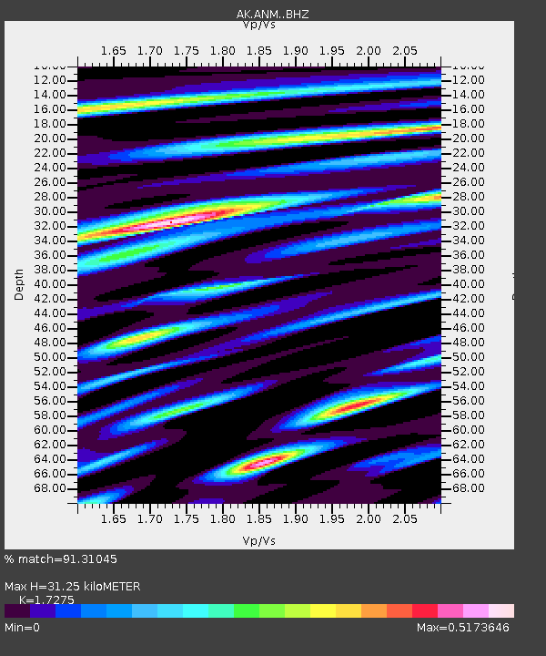
ANM Anvil Mountian - Earthquake Result Viewer
| Earthquake location: |
Banda Sea |
| Earthquake latitude/longitude: |
-6.5/129.8 |
| Earthquake time(UTC): |
2023/11/08 (312) 04:52:52 GMT |
| Earthquake Depth: |
10 km |
| Earthquake Magnitude: |
6.9 Mi |
| Earthquake Catalog/Contributor: |
NEIC PDE/pt |
|
| Network: |
AK Alaska Regional Network |
| Station: |
ANM Anvil Mountian |
| Lat/Lon: |
64.56 N/165.37 W |
| Elevation: |
330 m |
|
| Distance: |
85.3 deg |
| Az: |
23.099 deg |
| Baz: |
244.5 deg |
| Ray Param: |
0.044834096 |
| Estimated Moho Depth: |
31.25 km |
| Estimated Crust Vp/Vs: |
1.73 |
| Assumed Crust Vp: |
6.276 km/s |
| Estimated Crust Vs: |
3.633 km/s |
| Estimated Crust Poisson's Ratio: |
0.25 |
|
| Radial Match: |
91.31045 % |
| Radial Bump: |
400 |
| Transverse Match: |
79.8902 % |
| Transverse Bump: |
400 |
| SOD ConfigId: |
31937991 |
| Insert Time: |
2023-11-22 04:55:07.941 +0000 |
| GWidth: |
2.5 |
| Max Bumps: |
400 |
| Tol: |
0.001 |
|

Signal To Noise
| Channel | StoN | STA | LTA |
| AK:ANM: :BHZ:20231108T05:04:57.700012Z | 2.2929277 | 6.7644197E-7 | 2.950123E-7 |
| AK:ANM: :BHN:20231108T05:04:57.700012Z | 1.2609352 | 3.147866E-7 | 2.4964535E-7 |
| AK:ANM: :BHE:20231108T05:04:57.700012Z | 0.442594 | 2.1671809E-7 | 4.896544E-7 |
| Arrivals |
| Ps | 3.7 SECOND |
| PpPs | 13 SECOND |
| PsPs/PpSs | 17 SECOND |


