You are here: Home > Network List > G - GEOSCOPE Stations List
> Station INU Inuyama, Japan > Earthquake Result Viewer
INU Inuyama, Japan - Earthquake Result Viewer
| Earthquake location: |
Banda Sea |
| Earthquake latitude/longitude: |
-6.5/129.8 |
| Earthquake time(UTC): |
2023/11/08 (312) 04:52:52 GMT |
| Earthquake Depth: |
10 km |
| Earthquake Magnitude: |
6.9 Mi |
| Earthquake Catalog/Contributor: |
NEIC PDE/pt |
|
| Network: |
G GEOSCOPE |
| Station: |
INU Inuyama, Japan |
| Lat/Lon: |
35.35 N/137.03 E |
| Elevation: |
132 m |
|
| Distance: |
42.2 deg |
| Az: |
8.858 deg |
| Baz: |
190.788 deg |
| Ray Param: |
0.07333965 |
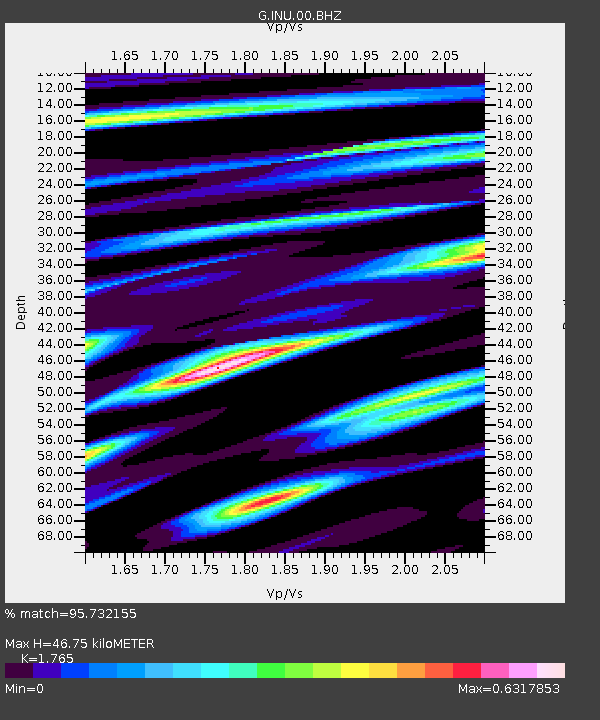
| Estimated Moho Depth: |
46.75 km |
| Estimated Crust Vp/Vs: |
1.76 |
| Assumed Crust Vp: |
6.461 km/s |
| Estimated Crust Vs: |
3.661 km/s |
| Estimated Crust Poisson's Ratio: |
0.26 |
|
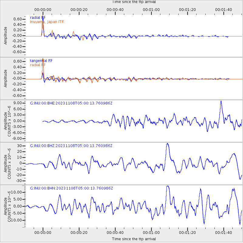
| Radial Match: |
95.732155 % |
| Radial Bump: |
379 |
| Transverse Match: |
75.847336 % |
| Transverse Bump: |
400 |
| SOD ConfigId: |
31937991 |
| Insert Time: |
2023-11-22 04:59:10.225 +0000 |
| GWidth: |
2.5 |
| Max Bumps: |
400 |
| Tol: |
0.001 |
|
Signal To Noise
| Channel | StoN | STA | LTA |
| G:INU:00:BHZ:20231108T05:00:13.760986Z | 10.349081 | 3.6014505E-6 | 3.4799714E-7 |
| G:INU:00:BHN:20231108T05:00:13.760986Z | 3.811784 | 1.7792553E-6 | 4.6677755E-7 |
| G:INU:00:BHE:20231108T05:00:13.760986Z | 1.2405673 | 4.383112E-7 | 3.5331513E-7 |
| Arrivals |
| Ps | 5.9 SECOND |
| PpPs | 19 SECOND |
| PsPs/PpSs | 25 SECOND |


