You are here: Home > Network List > TA - USArray Transportable Network (new EarthScope stations) Stations List
> Station Q31A Ellis, KS, USA > Earthquake Result Viewer
Q31A Ellis, KS, USA - Earthquake Result Viewer
| Earthquake location: |
Near Coast Of Central Chile |
| Earthquake latitude/longitude: |
-37.4/-73.3 |
| Earthquake time(UTC): |
2010/08/05 (217) 06:01:47 GMT |
| Earthquake Depth: |
18 km |
| Earthquake Magnitude: |
5.5 MS, 5.4 MB, 5.9 MW, 5.8 MW |
| Earthquake Catalog/Contributor: |
WHDF/NEIC |
|
| Network: |
TA USArray Transportable Network (new EarthScope stations) |
| Station: |
Q31A Ellis, KS, USA |
| Lat/Lon: |
39.00 N/99.39 W |
| Elevation: |
680 m |
|
| Distance: |
79.8 deg |
| Az: |
339.606 deg |
| Baz: |
159.147 deg |
| Ray Param: |
0.048709184 |
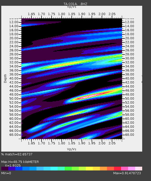
| Estimated Moho Depth: |
48.75 km |
| Estimated Crust Vp/Vs: |
1.93 |
| Assumed Crust Vp: |
6.483 km/s |
| Estimated Crust Vs: |
3.355 km/s |
| Estimated Crust Poisson's Ratio: |
0.32 |
|
| Radial Match: |
82.65737 % |
| Radial Bump: |
400 |
| Transverse Match: |
72.61409 % |
| Transverse Bump: |
400 |
| SOD ConfigId: |
319893 |
| Insert Time: |
2011-01-05 17:58:11.555 +0000 |
| GWidth: |
2.5 |
| Max Bumps: |
400 |
| Tol: |
0.001 |
|

Signal To Noise
| Channel | StoN | STA | LTA |
| TA:Q31A: :BHZ:20100805T06:13:23.049985Z | 3.273474 | 3.0969835E-7 | 9.460847E-8 |
| TA:Q31A: :BHN:20100805T06:13:23.049985Z | 3.0254593 | 1.7746987E-7 | 5.865882E-8 |
| TA:Q31A: :BHE:20100805T06:13:23.049985Z | 0.76547337 | 7.381272E-8 | 9.6427556E-8 |
| Arrivals |
| Ps | 7.2 SECOND |
| PpPs | 21 SECOND |
| PsPs/PpSs | 29 SECOND |


