You are here: Home > Network List > AZ - ANZA Regional Network Stations List
> Station BZN AZ.BZN > Earthquake Result Viewer
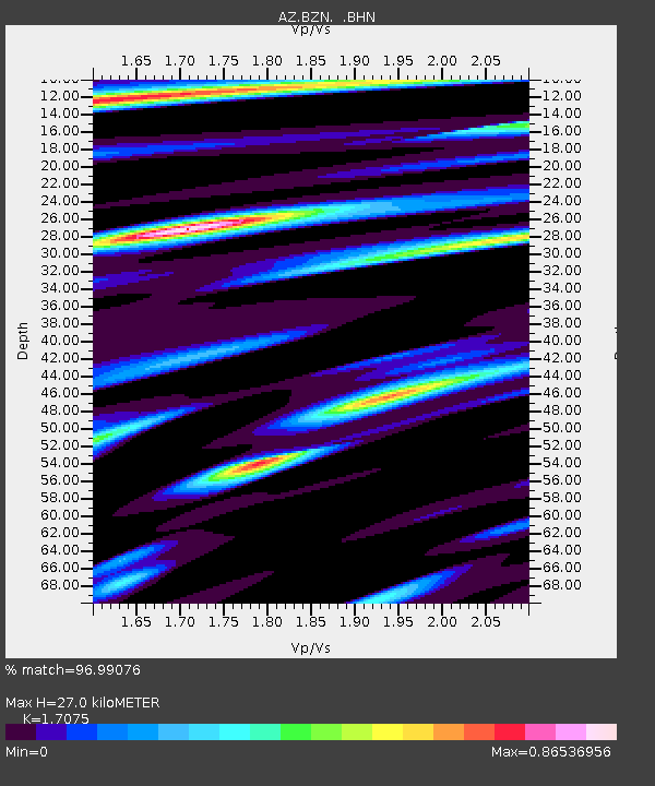
BZN AZ.BZN - Earthquake Result Viewer
| Earthquake location: |
Northern Peru |
| Earthquake latitude/longitude: |
-5.7/-76.4 |
| Earthquake time(UTC): |
2005/09/26 (269) 01:55:37 GMT |
| Earthquake Depth: |
115 km |
| Earthquake Magnitude: |
6.7 MB, 7.5 MW, 7.5 MW |
| Earthquake Catalog/Contributor: |
WHDF/NEIC |
|
| Network: |
AZ ANZA Regional Network |
| Station: |
BZN AZ.BZN |
| Lat/Lon: |
33.49 N/116.67 W |
| Elevation: |
1301 m |
|
| Distance: |
54.5 deg |
| Az: |
318.44 deg |
| Baz: |
127.813 deg |
| Ray Param: |
0.06504083 |
| Estimated Moho Depth: |
27.0 km |
| Estimated Crust Vp/Vs: |
1.71 |
| Assumed Crust Vp: |
6.264 km/s |
| Estimated Crust Vs: |
3.668 km/s |
| Estimated Crust Poisson's Ratio: |
0.24 |
|
| Radial Match: |
96.99076 % |
| Radial Bump: |
400 |
| Transverse Match: |
84.79121 % |
| Transverse Bump: |
400 |
| SOD ConfigId: |
2475 |
| Insert Time: |
2010-02-26 18:40:44.489 +0000 |
| GWidth: |
2.5 |
| Max Bumps: |
400 |
| Tol: |
0.001 |
|

Signal To Noise
| Channel | StoN | STA | LTA |
| AZ:BZN: :BHN:20050926T02:04:22.969011Z | 18.603764 | 4.129857E-6 | 2.219904E-7 |
| AZ:BZN: :BHE:20050926T02:04:22.969011Z | 29.519505 | 5.9763665E-6 | 2.0245484E-7 |
| AZ:BZN: :BHZ:20050926T02:04:22.969011Z | 49.226227 | 1.4282712E-5 | 2.9014436E-7 |
| Arrivals |
| Ps | 3.2 SECOND |
| PpPs | 11 SECOND |
| PsPs/PpSs | 14 SECOND |


