You are here: Home > Network List > AV - Alaska Volcano Observatory Stations List
> Station GSIG Igitkin Island, Great Sitkin Volcano, Alaska > Earthquake Result Viewer
GSIG Igitkin Island, Great Sitkin Volcano, Alaska - Earthquake Result Viewer
| Earthquake location: |
Banda Sea |
| Earthquake latitude/longitude: |
-6.5/129.4 |
| Earthquake time(UTC): |
2023/11/08 (312) 04:53:51 GMT |
| Earthquake Depth: |
10 km |
| Earthquake Magnitude: |
7.0 Mww |
| Earthquake Catalog/Contributor: |
NEIC PDE/us |
|
| Network: |
AV Alaska Volcano Observatory |
| Station: |
GSIG Igitkin Island, Great Sitkin Volcano, Alaska |
| Lat/Lon: |
51.99 N/175.93 W |
| Elevation: |
407 m |
|
| Distance: |
74.5 deg |
| Az: |
31.581 deg |
| Baz: |
237.291 deg |
| Ray Param: |
0.052270267 |
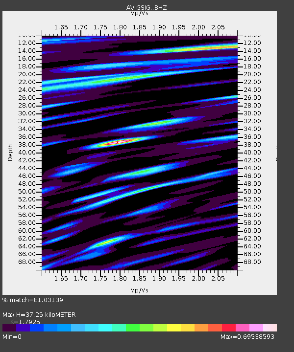
| Estimated Moho Depth: |
37.25 km |
| Estimated Crust Vp/Vs: |
1.79 |
| Assumed Crust Vp: |
3.943 km/s |
| Estimated Crust Vs: |
2.2 km/s |
| Estimated Crust Poisson's Ratio: |
0.27 |
|
| Radial Match: |
81.03139 % |
| Radial Bump: |
400 |
| Transverse Match: |
78.3057 % |
| Transverse Bump: |
400 |
| SOD ConfigId: |
31937991 |
| Insert Time: |
2023-11-22 05:06:24.533 +0000 |
| GWidth: |
2.5 |
| Max Bumps: |
400 |
| Tol: |
0.001 |
|
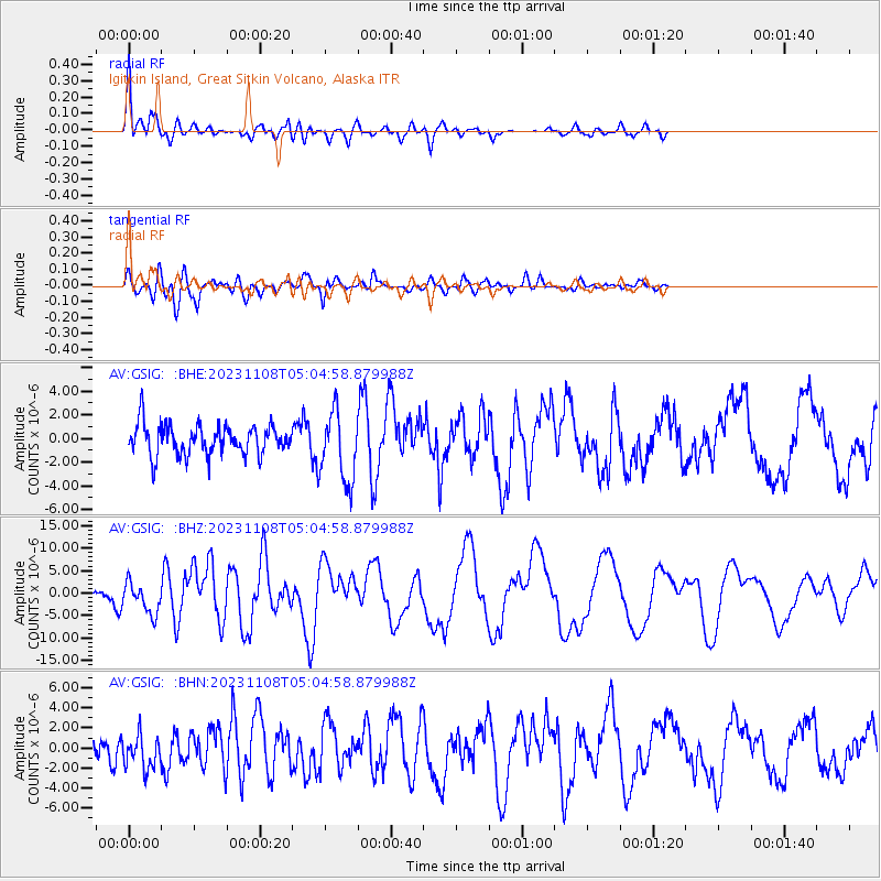
Signal To Noise
| Channel | StoN | STA | LTA |
| AV:GSIG: :BHZ:20231108T05:04:58.879988Z | 1.9915526 | 3.4832492E-6 | 1.7490119E-6 |
| AV:GSIG: :BHN:20231108T05:04:58.879988Z | 1.2311907 | 1.6658137E-6 | 1.3530104E-6 |
| AV:GSIG: :BHE:20231108T05:04:58.879988Z | 2.3703077 | 3.02775E-6 | 1.2773658E-6 |
| Arrivals |
| Ps | 7.6 SECOND |
| PpPs | 26 SECOND |
| PsPs/PpSs | 34 SECOND |


