You are here: Home > Network List > IU - Global Seismograph Network (GSN - IRIS/USGS) Stations List
> Station MA2 Magadan, Russia > Earthquake Result Viewer
MA2 Magadan, Russia - Earthquake Result Viewer
| Earthquake location: |
Banda Sea |
| Earthquake latitude/longitude: |
-6.5/129.4 |
| Earthquake time(UTC): |
2023/11/08 (312) 04:53:51 GMT |
| Earthquake Depth: |
10 km |
| Earthquake Magnitude: |
7.0 Mww |
| Earthquake Catalog/Contributor: |
NEIC PDE/us |
|
| Network: |
IU Global Seismograph Network (GSN - IRIS/USGS) |
| Station: |
MA2 Magadan, Russia |
| Lat/Lon: |
59.58 N/150.77 E |
| Elevation: |
339 m |
|
| Distance: |
68.1 deg |
| Az: |
11.551 deg |
| Baz: |
203.013 deg |
| Ray Param: |
0.056559287 |
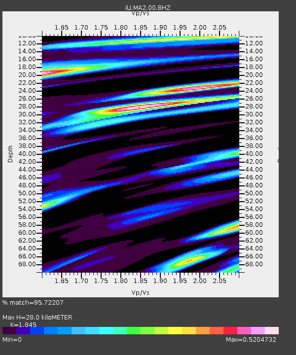
| Estimated Moho Depth: |
28.0 km |
| Estimated Crust Vp/Vs: |
1.85 |
| Assumed Crust Vp: |
6.134 km/s |
| Estimated Crust Vs: |
3.325 km/s |
| Estimated Crust Poisson's Ratio: |
0.29 |
|
| Radial Match: |
95.72207 % |
| Radial Bump: |
400 |
| Transverse Match: |
82.21588 % |
| Transverse Bump: |
400 |
| SOD ConfigId: |
31937991 |
| Insert Time: |
2023-11-22 05:09:24.679 +0000 |
| GWidth: |
2.5 |
| Max Bumps: |
400 |
| Tol: |
0.001 |
|

Signal To Noise
| Channel | StoN | STA | LTA |
| IU:MA2:00:BHZ:20231108T05:04:19.718977Z | 1.9519708 | 5.081727E-6 | 2.6033827E-6 |
| IU:MA2:00:BH1:20231108T05:04:19.718977Z | 1.9623199 | 2.0857992E-6 | 1.0629252E-6 |
| IU:MA2:00:BH2:20231108T05:04:19.718977Z | 1.6043509 | 1.0389913E-6 | 6.476085E-7 |
| Arrivals |
| Ps | 4.0 SECOND |
| PpPs | 13 SECOND |
| PsPs/PpSs | 17 SECOND |


