You are here: Home > Network List > US - United States National Seismic Network Stations List
> Station EGMT Eagleton, Montana, USA > Earthquake Result Viewer
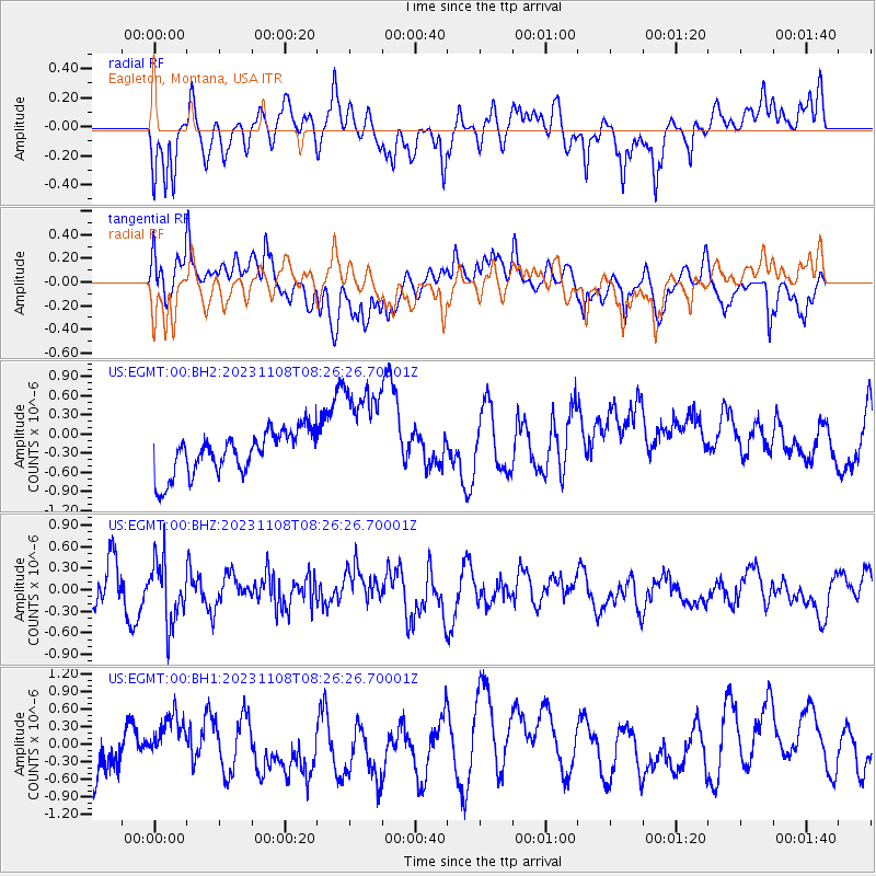
EGMT Eagleton, Montana, USA - Earthquake Result Viewer
*The percent match for this event was below the threshold and hence no stack was calculated.
| Earthquake location: |
Kuril Islands |
| Earthquake latitude/longitude: |
45.0/149.8 |
| Earthquake time(UTC): |
2023/11/08 (312) 08:16:29 GMT |
| Earthquake Depth: |
68 km |
| Earthquake Magnitude: |
5.6 mb |
| Earthquake Catalog/Contributor: |
NEIC PDE/us |
|
| Network: |
US United States National Seismic Network |
| Station: |
EGMT Eagleton, Montana, USA |
| Lat/Lon: |
48.02 N/109.75 W |
| Elevation: |
1055 m |
|
| Distance: |
64.2 deg |
| Az: |
47.149 deg |
| Baz: |
309.156 deg |
| Ray Param: |
$rayparam |
*The percent match for this event was below the threshold and hence was not used in the summary stack. |
|
| Radial Match: |
58.381767 % |
| Radial Bump: |
400 |
| Transverse Match: |
64.86435 % |
| Transverse Bump: |
400 |
| SOD ConfigId: |
31937991 |
| Insert Time: |
2023-11-22 08:42:59.679 +0000 |
| GWidth: |
2.5 |
| Max Bumps: |
400 |
| Tol: |
0.001 |
|
Signal To Noise
| Channel | StoN | STA | LTA |
| US:EGMT:00:BHZ:20231108T08:26:26.70001Z | 1.630105 | 4.4199254E-7 | 2.711436E-7 |
| US:EGMT:00:BH1:20231108T08:26:26.70001Z | 0.72399163 | 2.9927227E-7 | 4.133643E-7 |
| US:EGMT:00:BH2:20231108T08:26:26.70001Z | 2.4623513 | 8.2529465E-7 | 3.3516525E-7 |
| Arrivals |
| Ps | |
| PpPs | |
| PsPs/PpSs | |


