You are here: Home > Network List > TA - USArray Transportable Network (new EarthScope stations) Stations List
> Station 434A Burnet, TX, USA > Earthquake Result Viewer
434A Burnet, TX, USA - Earthquake Result Viewer
| Earthquake location: |
Near Coast Of Central Chile |
| Earthquake latitude/longitude: |
-37.4/-73.3 |
| Earthquake time(UTC): |
2010/08/05 (217) 06:01:47 GMT |
| Earthquake Depth: |
18 km |
| Earthquake Magnitude: |
5.5 MS, 5.4 MB, 5.9 MW, 5.8 MW |
| Earthquake Catalog/Contributor: |
WHDF/NEIC |
|
| Network: |
TA USArray Transportable Network (new EarthScope stations) |
| Station: |
434A Burnet, TX, USA |
| Lat/Lon: |
30.81 N/98.27 W |
| Elevation: |
462 m |
|
| Distance: |
71.8 deg |
| Az: |
337.509 deg |
| Baz: |
159.274 deg |
| Ray Param: |
0.054060355 |
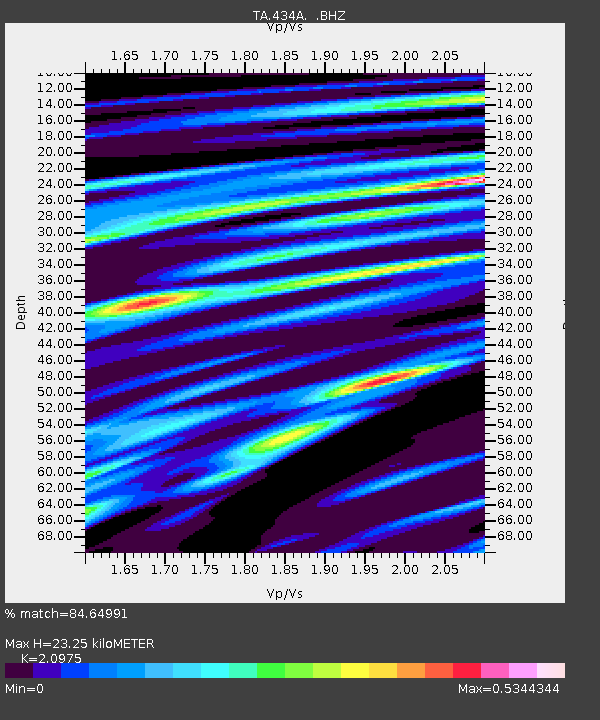
| Estimated Moho Depth: |
23.25 km |
| Estimated Crust Vp/Vs: |
2.10 |
| Assumed Crust Vp: |
6.498 km/s |
| Estimated Crust Vs: |
3.098 km/s |
| Estimated Crust Poisson's Ratio: |
0.35 |
|
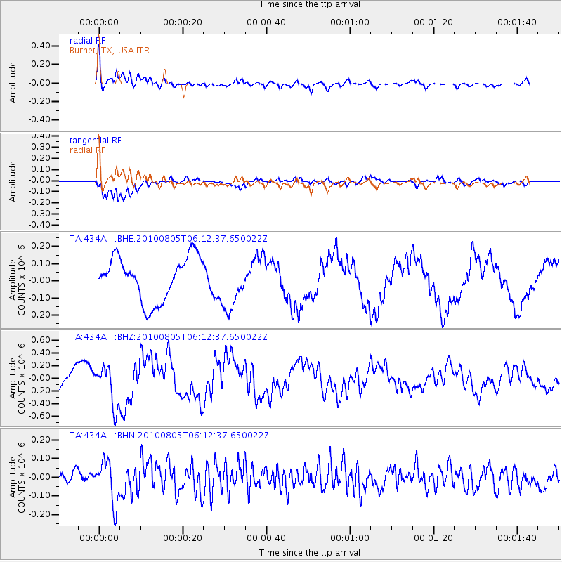
| Radial Match: |
84.64991 % |
| Radial Bump: |
400 |
| Transverse Match: |
94.25348 % |
| Transverse Bump: |
366 |
| SOD ConfigId: |
319893 |
| Insert Time: |
2011-01-05 18:04:54.337 +0000 |
| GWidth: |
2.5 |
| Max Bumps: |
400 |
| Tol: |
0.001 |
|
Signal To Noise
| Channel | StoN | STA | LTA |
| TA:434A: :BHZ:20100805T06:12:37.650022Z | 1.781968 | 3.2167353E-7 | 1.8051588E-7 |
| TA:434A: :BHN:20100805T06:12:37.650022Z | 3.521049 | 1.1673718E-7 | 3.315409E-8 |
| TA:434A: :BHE:20100805T06:12:37.650022Z | 1.2149646 | 1.5215262E-7 | 1.2523213E-7 |
| Arrivals |
| Ps | 4.0 SECOND |
| PpPs | 11 SECOND |
| PsPs/PpSs | 15 SECOND |


