You are here: Home > Network List > G - GEOSCOPE Stations List
> Station INU Inuyama, Japan > Earthquake Result Viewer
INU Inuyama, Japan - Earthquake Result Viewer
| Earthquake location: |
Banda Sea |
| Earthquake latitude/longitude: |
-6.1/129.9 |
| Earthquake time(UTC): |
2023/11/08 (312) 13:02:06 GMT |
| Earthquake Depth: |
10 km |
| Earthquake Magnitude: |
6.7 mww |
| Earthquake Catalog/Contributor: |
NEIC PDE/us |
|
| Network: |
G GEOSCOPE |
| Station: |
INU Inuyama, Japan |
| Lat/Lon: |
35.35 N/137.03 E |
| Elevation: |
132 m |
|
| Distance: |
41.8 deg |
| Az: |
8.735 deg |
| Baz: |
190.646 deg |
| Ray Param: |
0.07355609 |
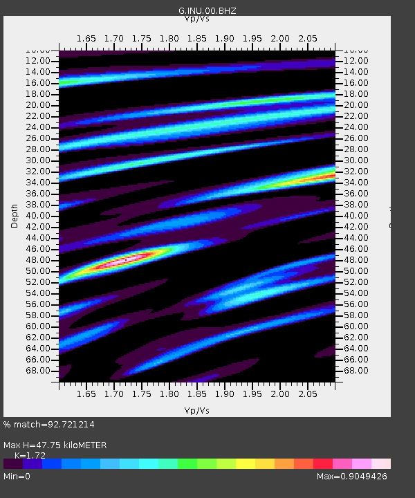
| Estimated Moho Depth: |
47.75 km |
| Estimated Crust Vp/Vs: |
1.72 |
| Assumed Crust Vp: |
6.461 km/s |
| Estimated Crust Vs: |
3.757 km/s |
| Estimated Crust Poisson's Ratio: |
0.24 |
|
| Radial Match: |
92.721214 % |
| Radial Bump: |
262 |
| Transverse Match: |
77.33609 % |
| Transverse Bump: |
375 |
| SOD ConfigId: |
31937991 |
| Insert Time: |
2023-11-22 13:09:05.105 +0000 |
| GWidth: |
2.5 |
| Max Bumps: |
400 |
| Tol: |
0.001 |
|
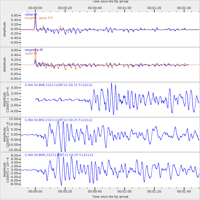
Signal To Noise
| Channel | StoN | STA | LTA |
| G:INU:00:BHZ:20231108T13:09:25.511011Z | 3.514507 | 9.572713E-7 | 2.723771E-7 |
| G:INU:00:BHN:20231108T13:09:25.511011Z | 2.1966386 | 4.802165E-7 | 2.1861426E-7 |
| G:INU:00:BHE:20231108T13:09:25.511011Z | 1.0547153 | 2.609975E-7 | 2.474578E-7 |
| Arrivals |
| Ps | 5.7 SECOND |
| PpPs | 19 SECOND |
| PsPs/PpSs | 24 SECOND |


