You are here: Home > Network List > TA - USArray Transportable Network (new EarthScope stations) Stations List
> Station Z37A Pogue Cattle Company, Sulphur Springs, TX, USA > Earthquake Result Viewer
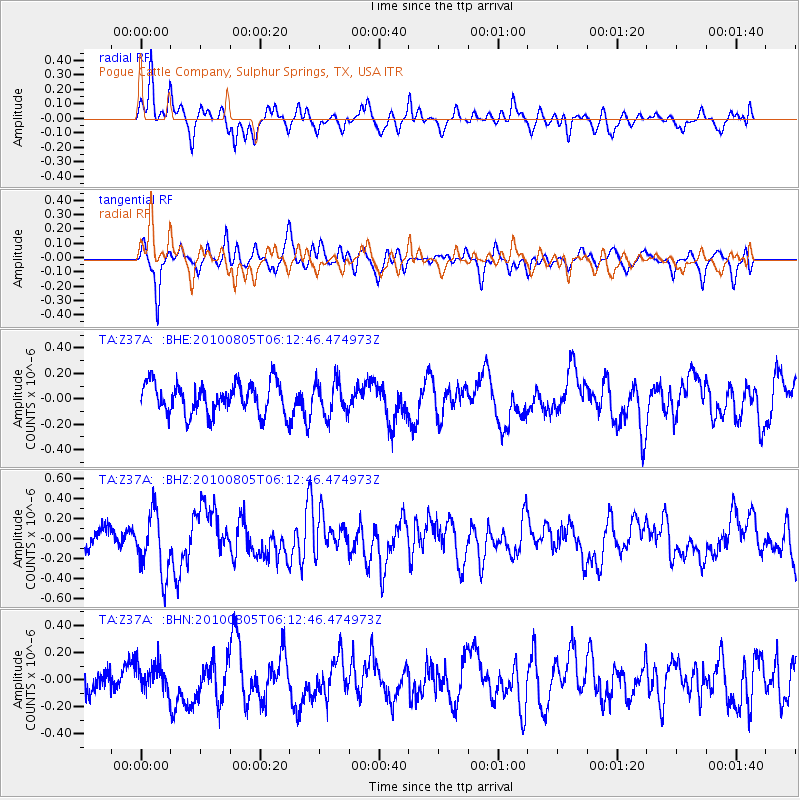
Z37A Pogue Cattle Company, Sulphur Springs, TX, USA - Earthquake Result Viewer
*The percent match for this event was below the threshold and hence no stack was calculated.
| Earthquake location: |
Near Coast Of Central Chile |
| Earthquake latitude/longitude: |
-37.4/-73.3 |
| Earthquake time(UTC): |
2010/08/05 (217) 06:01:47 GMT |
| Earthquake Depth: |
18 km |
| Earthquake Magnitude: |
5.5 MS, 5.4 MB, 5.9 MW, 5.8 MW |
| Earthquake Catalog/Contributor: |
WHDF/NEIC |
|
| Network: |
TA USArray Transportable Network (new EarthScope stations) |
| Station: |
Z37A Pogue Cattle Company, Sulphur Springs, TX, USA |
| Lat/Lon: |
33.20 N/95.62 W |
| Elevation: |
146 m |
|
| Distance: |
73.3 deg |
| Az: |
340.564 deg |
| Baz: |
161.586 deg |
| Ray Param: |
$rayparam |
*The percent match for this event was below the threshold and hence was not used in the summary stack. |
|
| Radial Match: |
65.7373 % |
| Radial Bump: |
400 |
| Transverse Match: |
68.14168 % |
| Transverse Bump: |
387 |
| SOD ConfigId: |
319893 |
| Insert Time: |
2011-01-05 18:09:00.287 +0000 |
| GWidth: |
2.5 |
| Max Bumps: |
400 |
| Tol: |
0.001 |
|
Signal To Noise
| Channel | StoN | STA | LTA |
| TA:Z37A: :BHZ:20100805T06:12:46.474973Z | 2.9421985 | 3.0681116E-7 | 1.0427956E-7 |
| TA:Z37A: :BHN:20100805T06:12:46.474973Z | 0.79056597 | 9.734854E-8 | 1.2313778E-7 |
| TA:Z37A: :BHE:20100805T06:12:46.474973Z | 1.0962589 | 1.3127648E-7 | 1.1974953E-7 |
| Arrivals |
| Ps | |
| PpPs | |
| PsPs/PpSs | |


