You are here: Home > Network List > TM - Thai Seismic Monitoring Network Stations List
> Station PANO PANO staion > Earthquake Result Viewer
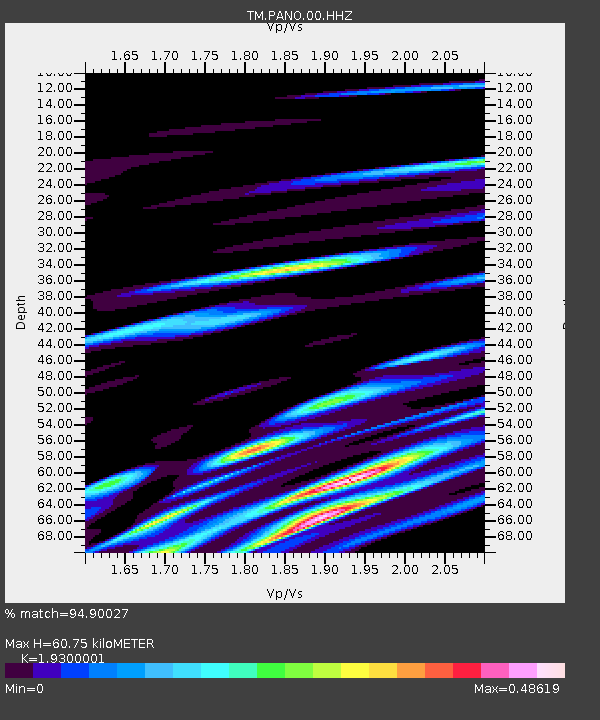
PANO PANO staion - Earthquake Result Viewer
| Earthquake location: |
Banda Sea |
| Earthquake latitude/longitude: |
-6.1/130.2 |
| Earthquake time(UTC): |
2023/11/10 (314) 03:50:35 GMT |
| Earthquake Depth: |
10 km |
| Earthquake Magnitude: |
5.9 mww |
| Earthquake Catalog/Contributor: |
NEIC PDE/us |
|
| Network: |
TM Thai Seismic Monitoring Network |
| Station: |
PANO PANO staion |
| Lat/Lon: |
17.15 N/104.61 E |
| Elevation: |
136 m |
|
| Distance: |
34.2 deg |
| Az: |
312.767 deg |
| Baz: |
130.219 deg |
| Ray Param: |
0.07784659 |
| Estimated Moho Depth: |
60.75 km |
| Estimated Crust Vp/Vs: |
1.93 |
| Assumed Crust Vp: |
6.498 km/s |
| Estimated Crust Vs: |
3.367 km/s |
| Estimated Crust Poisson's Ratio: |
0.32 |
|
| Radial Match: |
94.90027 % |
| Radial Bump: |
395 |
| Transverse Match: |
93.486336 % |
| Transverse Bump: |
400 |
| SOD ConfigId: |
31937991 |
| Insert Time: |
2023-11-24 03:58:33.500 +0000 |
| GWidth: |
2.5 |
| Max Bumps: |
400 |
| Tol: |
0.001 |
|

Signal To Noise
| Channel | StoN | STA | LTA |
| TM:PANO:00:HHZ:20231110T03:56:50.200002Z | 5.979046 | 1.0743785E-7 | 1.7969063E-8 |
| TM:PANO:00:HHN:20231110T03:56:50.200002Z | 1.244466 | 2.0309464E-8 | 1.6319824E-8 |
| TM:PANO:00:HHE:20231110T03:56:50.200002Z | 1.001257 | 1.6852029E-8 | 1.6830873E-8 |
| Arrivals |
| Ps | 9.3 SECOND |
| PpPs | 25 SECOND |
| PsPs/PpSs | 35 SECOND |


