You are here: Home > Network List > TA - USArray Transportable Network (new EarthScope stations) Stations List
> Station O33A Hebron, NE, USA > Earthquake Result Viewer
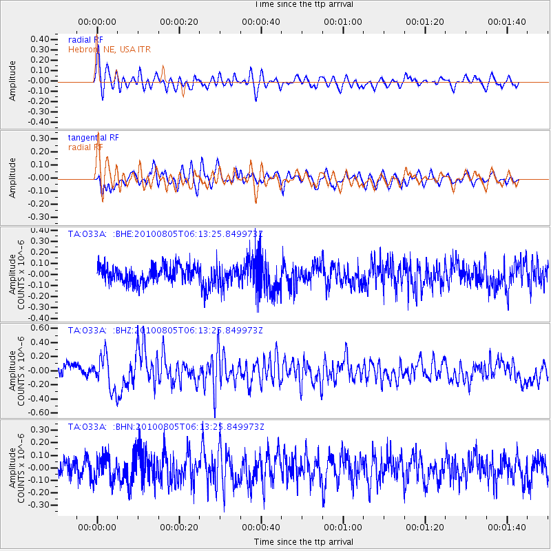
O33A Hebron, NE, USA - Earthquake Result Viewer
*The percent match for this event was below the threshold and hence no stack was calculated.
| Earthquake location: |
Near Coast Of Central Chile |
| Earthquake latitude/longitude: |
-37.4/-73.3 |
| Earthquake time(UTC): |
2010/08/05 (217) 06:01:47 GMT |
| Earthquake Depth: |
18 km |
| Earthquake Magnitude: |
5.5 MS, 5.4 MB, 5.9 MW, 5.8 MW |
| Earthquake Catalog/Contributor: |
WHDF/NEIC |
|
| Network: |
TA USArray Transportable Network (new EarthScope stations) |
| Station: |
O33A Hebron, NE, USA |
| Lat/Lon: |
40.08 N/97.58 W |
| Elevation: |
480 m |
|
| Distance: |
80.3 deg |
| Az: |
341.314 deg |
| Baz: |
160.59 deg |
| Ray Param: |
$rayparam |
*The percent match for this event was below the threshold and hence was not used in the summary stack. |
|
| Radial Match: |
66.35252 % |
| Radial Bump: |
400 |
| Transverse Match: |
76.47016 % |
| Transverse Bump: |
400 |
| SOD ConfigId: |
319893 |
| Insert Time: |
2011-01-05 18:10:28.314 +0000 |
| GWidth: |
2.5 |
| Max Bumps: |
400 |
| Tol: |
0.001 |
|
Signal To Noise
| Channel | StoN | STA | LTA |
| TA:O33A: :BHZ:20100805T06:13:25.849973Z | 2.9323559 | 2.4294943E-7 | 8.285127E-8 |
| TA:O33A: :BHN:20100805T06:13:25.849973Z | 1.2920154 | 9.4784646E-8 | 7.336186E-8 |
| TA:O33A: :BHE:20100805T06:13:25.849973Z | 1.1962434 | 8.7947136E-8 | 7.351943E-8 |
| Arrivals |
| Ps | |
| PpPs | |
| PsPs/PpSs | |


