You are here: Home > Network List > CI - Caltech Regional Seismic Network Stations List
> Station LRL Laurel Mtn Radio Fac, Ridgecrest, CA, USA > Earthquake Result Viewer
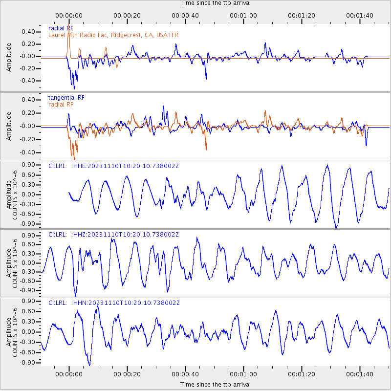
LRL Laurel Mtn Radio Fac, Ridgecrest, CA, USA - Earthquake Result Viewer
*The percent match for this event was below the threshold and hence no stack was calculated.
| Earthquake location: |
Kuril Islands |
| Earthquake latitude/longitude: |
45.9/151.0 |
| Earthquake time(UTC): |
2023/11/10 (314) 10:10:04 GMT |
| Earthquake Depth: |
107 km |
| Earthquake Magnitude: |
5.8 mww |
| Earthquake Catalog/Contributor: |
NEIC PDE/us |
|
| Network: |
CI Caltech Regional Seismic Network |
| Station: |
LRL Laurel Mtn Radio Fac, Ridgecrest, CA, USA |
| Lat/Lon: |
35.48 N/117.68 W |
| Elevation: |
1340 m |
|
| Distance: |
66.4 deg |
| Az: |
62.936 deg |
| Baz: |
310.37 deg |
| Ray Param: |
$rayparam |
*The percent match for this event was below the threshold and hence was not used in the summary stack. |
|
| Radial Match: |
71.818535 % |
| Radial Bump: |
400 |
| Transverse Match: |
59.684486 % |
| Transverse Bump: |
348 |
| SOD ConfigId: |
31937991 |
| Insert Time: |
2023-11-24 10:20:34.935 +0000 |
| GWidth: |
2.5 |
| Max Bumps: |
400 |
| Tol: |
0.001 |
|
Signal To Noise
| Channel | StoN | STA | LTA |
| CI:LRL: :HHZ:20231110T10:20:10.738002Z | 2.220295 | 5.470592E-7 | 2.4639033E-7 |
| CI:LRL: :HHN:20231110T10:20:10.738002Z | 1.2286977 | 4.0544646E-7 | 3.2998068E-7 |
| CI:LRL: :HHE:20231110T10:20:10.738002Z | 0.8629685 | 2.907859E-7 | 3.3696003E-7 |
| Arrivals |
| Ps | |
| PpPs | |
| PsPs/PpSs | |


