You are here: Home > Network List > CI - Caltech Regional Seismic Network Stations List
> Station MPP McPhearson Peak > Earthquake Result Viewer
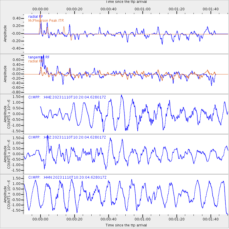
MPP McPhearson Peak - Earthquake Result Viewer
*The percent match for this event was below the threshold and hence no stack was calculated.
| Earthquake location: |
Kuril Islands |
| Earthquake latitude/longitude: |
45.9/151.0 |
| Earthquake time(UTC): |
2023/11/10 (314) 10:10:04 GMT |
| Earthquake Depth: |
107 km |
| Earthquake Magnitude: |
5.8 mww |
| Earthquake Catalog/Contributor: |
NEIC PDE/us |
|
| Network: |
CI Caltech Regional Seismic Network |
| Station: |
MPP McPhearson Peak |
| Lat/Lon: |
34.89 N/119.81 W |
| Elevation: |
1739 m |
|
| Distance: |
65.4 deg |
| Az: |
64.662 deg |
| Baz: |
309.851 deg |
| Ray Param: |
$rayparam |
*The percent match for this event was below the threshold and hence was not used in the summary stack. |
|
| Radial Match: |
59.128315 % |
| Radial Bump: |
397 |
| Transverse Match: |
77.46873 % |
| Transverse Bump: |
400 |
| SOD ConfigId: |
31937991 |
| Insert Time: |
2023-11-24 10:20:40.605 +0000 |
| GWidth: |
2.5 |
| Max Bumps: |
400 |
| Tol: |
0.001 |
|
Signal To Noise
| Channel | StoN | STA | LTA |
| CI:MPP: :HHZ:20231110T10:20:04.628017Z | 2.427518 | 7.9519424E-7 | 3.27575E-7 |
| CI:MPP: :HHN:20231110T10:20:04.628017Z | 1.2761909 | 8.5730227E-7 | 6.7176654E-7 |
| CI:MPP: :HHE:20231110T10:20:04.628017Z | 1.8311341 | 7.6129453E-7 | 4.1575026E-7 |
| Arrivals |
| Ps | |
| PpPs | |
| PsPs/PpSs | |


