You are here: Home > Network List > TM - Thai Seismic Monitoring Network Stations List
> Station PANO PANO staion > Earthquake Result Viewer
PANO PANO staion - Earthquake Result Viewer
| Earthquake location: |
Kuril Islands |
| Earthquake latitude/longitude: |
45.9/151.0 |
| Earthquake time(UTC): |
2023/11/10 (314) 10:10:04 GMT |
| Earthquake Depth: |
107 km |
| Earthquake Magnitude: |
5.8 mww |
| Earthquake Catalog/Contributor: |
NEIC PDE/us |
|
| Network: |
TM Thai Seismic Monitoring Network |
| Station: |
PANO PANO staion |
| Lat/Lon: |
17.15 N/104.61 E |
| Elevation: |
136 m |
|
| Distance: |
47.9 deg |
| Az: |
248.877 deg |
| Baz: |
42.943 deg |
| Ray Param: |
0.06934417 |
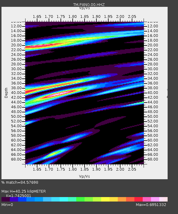
| Estimated Moho Depth: |
40.25 km |
| Estimated Crust Vp/Vs: |
1.74 |
| Assumed Crust Vp: |
6.498 km/s |
| Estimated Crust Vs: |
3.729 km/s |
| Estimated Crust Poisson's Ratio: |
0.25 |
|
| Radial Match: |
84.57698 % |
| Radial Bump: |
400 |
| Transverse Match: |
83.98814 % |
| Transverse Bump: |
400 |
| SOD ConfigId: |
31937991 |
| Insert Time: |
2023-11-24 10:37:18.977 +0000 |
| GWidth: |
2.5 |
| Max Bumps: |
400 |
| Tol: |
0.001 |
|

Signal To Noise
| Channel | StoN | STA | LTA |
| TM:PANO:00:HHZ:20231110T10:18:00.989986Z | 17.344702 | 2.110201E-7 | 1.2166257E-8 |
| TM:PANO:00:HHN:20231110T10:18:00.989986Z | 4.7368627 | 6.609474E-8 | 1.3953273E-8 |
| TM:PANO:00:HHE:20231110T10:18:00.989986Z | 1.5176786 | 1.8038346E-8 | 1.1885485E-8 |
| Arrivals |
| Ps | 4.9 SECOND |
| PpPs | 16 SECOND |
| PsPs/PpSs | 21 SECOND |


