You are here: Home > Network List > US - United States National Seismic Network Stations List
> Station DGMT Dagmar, Montana, USA > Earthquake Result Viewer
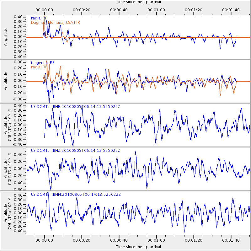
DGMT Dagmar, Montana, USA - Earthquake Result Viewer
*The percent match for this event was below the threshold and hence no stack was calculated.
| Earthquake location: |
Near Coast Of Central Chile |
| Earthquake latitude/longitude: |
-37.4/-73.3 |
| Earthquake time(UTC): |
2010/08/05 (217) 06:01:47 GMT |
| Earthquake Depth: |
18 km |
| Earthquake Magnitude: |
5.5 MS, 5.4 MB, 5.9 MW, 5.8 MW |
| Earthquake Catalog/Contributor: |
WHDF/NEIC |
|
| Network: |
US United States National Seismic Network |
| Station: |
DGMT Dagmar, Montana, USA |
| Lat/Lon: |
48.47 N/104.20 W |
| Elevation: |
0.0 m |
|
| Distance: |
89.9 deg |
| Az: |
340.007 deg |
| Baz: |
155.864 deg |
| Ray Param: |
$rayparam |
*The percent match for this event was below the threshold and hence was not used in the summary stack. |
|
| Radial Match: |
50.439537 % |
| Radial Bump: |
400 |
| Transverse Match: |
61.17892 % |
| Transverse Bump: |
340 |
| SOD ConfigId: |
319893 |
| Insert Time: |
2011-01-05 18:15:45.378 +0000 |
| GWidth: |
2.5 |
| Max Bumps: |
400 |
| Tol: |
0.001 |
|
Signal To Noise
| Channel | StoN | STA | LTA |
| US:DGMT: :BHZ:20100805T06:14:13.525022Z | 2.4601138 | 2.6309618E-7 | 1.0694472E-7 |
| US:DGMT: :BHN:20100805T06:14:13.525022Z | 1.6998818 | 2.470928E-7 | 1.4535881E-7 |
| US:DGMT: :BHE:20100805T06:14:13.525022Z | 0.7582415 | 1.3660483E-7 | 1.8016006E-7 |
| Arrivals |
| Ps | |
| PpPs | |
| PsPs/PpSs | |


