You are here: Home > Network List > US - United States National Seismic Network Stations List
> Station ELK Elko, Nevada, USA > Earthquake Result Viewer
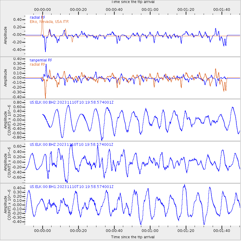
ELK Elko, Nevada, USA - Earthquake Result Viewer
*The percent match for this event was below the threshold and hence no stack was calculated.
| Earthquake location: |
Kuril Islands |
| Earthquake latitude/longitude: |
45.9/151.0 |
| Earthquake time(UTC): |
2023/11/10 (314) 10:10:04 GMT |
| Earthquake Depth: |
107 km |
| Earthquake Magnitude: |
5.8 mww |
| Earthquake Catalog/Contributor: |
NEIC PDE/us |
|
| Network: |
US United States National Seismic Network |
| Station: |
ELK Elko, Nevada, USA |
| Lat/Lon: |
40.74 N/115.24 W |
| Elevation: |
2210 m |
|
| Distance: |
64.5 deg |
| Az: |
57.143 deg |
| Baz: |
309.463 deg |
| Ray Param: |
$rayparam |
*The percent match for this event was below the threshold and hence was not used in the summary stack. |
|
| Radial Match: |
71.241325 % |
| Radial Bump: |
305 |
| Transverse Match: |
56.286556 % |
| Transverse Bump: |
249 |
| SOD ConfigId: |
31937991 |
| Insert Time: |
2023-11-24 10:40:11.825 +0000 |
| GWidth: |
2.5 |
| Max Bumps: |
400 |
| Tol: |
0.001 |
|
Signal To Noise
| Channel | StoN | STA | LTA |
| US:ELK:00:BHZ:20231110T10:19:58.574001Z | 1.2958221 | 2.9731754E-7 | 2.2944316E-7 |
| US:ELK:00:BH1:20231110T10:19:58.574001Z | 0.44988042 | 8.5671914E-8 | 1.9043264E-7 |
| US:ELK:00:BH2:20231110T10:19:58.574001Z | 1.4656206 | 5.1997506E-7 | 3.5478146E-7 |
| Arrivals |
| Ps | |
| PpPs | |
| PsPs/PpSs | |


