You are here: Home > Network List > IU - Global Seismograph Network (GSN - IRIS/USGS) Stations List
> Station FURI Mt. Furi, Ethiopia > Earthquake Result Viewer
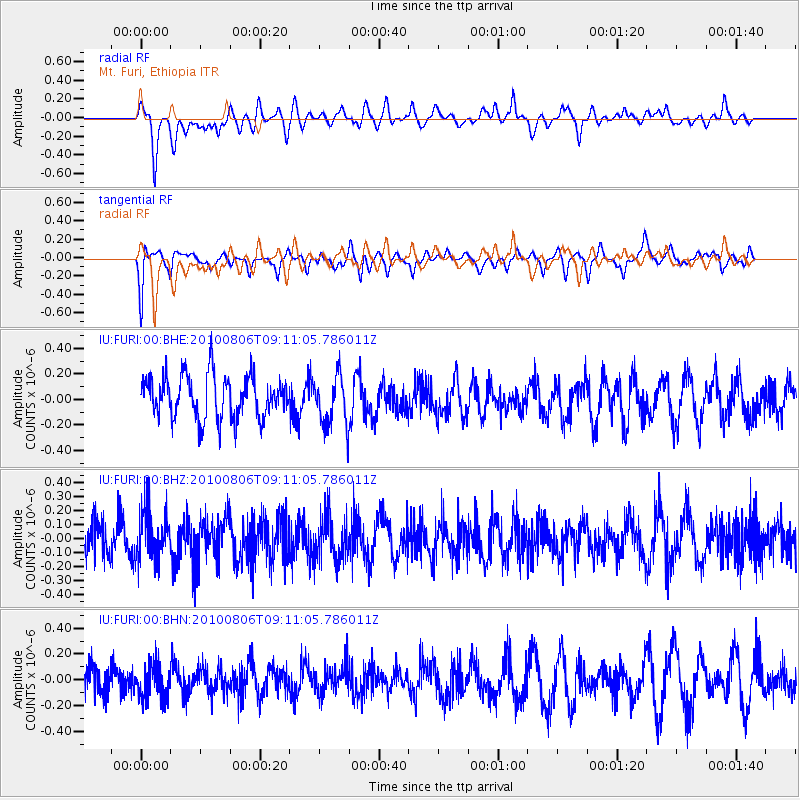
FURI Mt. Furi, Ethiopia - Earthquake Result Viewer
*The percent match for this event was below the threshold and hence no stack was calculated.
| Earthquake location: |
Banda Sea |
| Earthquake latitude/longitude: |
-7.4/128.5 |
| Earthquake time(UTC): |
2010/08/06 (218) 08:58:39 GMT |
| Earthquake Depth: |
57 km |
| Earthquake Magnitude: |
5.5 MB |
| Earthquake Catalog/Contributor: |
WHDF/NEIC |
|
| Network: |
IU Global Seismograph Network (GSN - IRIS/USGS) |
| Station: |
FURI Mt. Furi, Ethiopia |
| Lat/Lon: |
8.90 N/38.68 E |
| Elevation: |
2570 m |
|
| Distance: |
90.9 deg |
| Az: |
278.793 deg |
| Baz: |
97.299 deg |
| Ray Param: |
$rayparam |
*The percent match for this event was below the threshold and hence was not used in the summary stack. |
|
| Radial Match: |
60.38704 % |
| Radial Bump: |
400 |
| Transverse Match: |
59.6614 % |
| Transverse Bump: |
333 |
| SOD ConfigId: |
319893 |
| Insert Time: |
2011-01-05 18:19:50.706 +0000 |
| GWidth: |
2.5 |
| Max Bumps: |
400 |
| Tol: |
0.001 |
|
Signal To Noise
| Channel | StoN | STA | LTA |
| IU:FURI:00:BHZ:20100806T09:11:05.786011Z | 1.0782117 | 1.7642296E-7 | 1.6362554E-7 |
| IU:FURI:00:BHN:20100806T09:11:05.786011Z | 1.0652308 | 1.325197E-7 | 1.2440468E-7 |
| IU:FURI:00:BHE:20100806T09:11:05.786011Z | 1.2011058 | 1.9915623E-7 | 1.6581072E-7 |
| Arrivals |
| Ps | |
| PpPs | |
| PsPs/PpSs | |


