You are here: Home > Network List > IW - Intermountain West Stations List
> Station MOOW Moose Ponds, Wyoming, USA > Earthquake Result Viewer
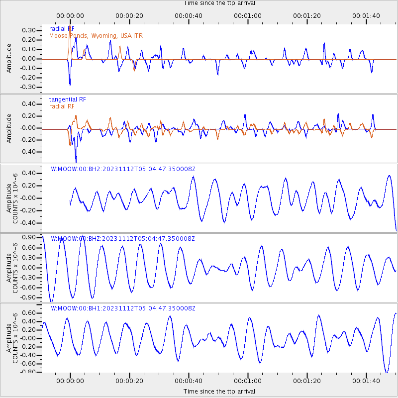
MOOW Moose Ponds, Wyoming, USA - Earthquake Result Viewer
*The percent match for this event was below the threshold and hence no stack was calculated.
| Earthquake location: |
New Ireland Region, P.N.G. |
| Earthquake latitude/longitude: |
-3.6/151.3 |
| Earthquake time(UTC): |
2023/11/12 (316) 04:51:41 GMT |
| Earthquake Depth: |
10 km |
| Earthquake Magnitude: |
5.9 mww |
| Earthquake Catalog/Contributor: |
NEIC PDE/us |
|
| Network: |
IW Intermountain West |
| Station: |
MOOW Moose Ponds, Wyoming, USA |
| Lat/Lon: |
43.75 N/110.74 W |
| Elevation: |
2128 m |
|
| Distance: |
98.2 deg |
| Az: |
46.488 deg |
| Baz: |
272.859 deg |
| Ray Param: |
$rayparam |
*The percent match for this event was below the threshold and hence was not used in the summary stack. |
|
| Radial Match: |
66.68966 % |
| Radial Bump: |
400 |
| Transverse Match: |
70.29294 % |
| Transverse Bump: |
400 |
| SOD ConfigId: |
31937991 |
| Insert Time: |
2023-11-26 05:03:12.655 +0000 |
| GWidth: |
2.5 |
| Max Bumps: |
400 |
| Tol: |
0.001 |
|
Signal To Noise
| Channel | StoN | STA | LTA |
| IW:MOOW:00:BHZ:20231112T05:04:47.350008Z | 1.4196243 | 6.774505E-7 | 4.772041E-7 |
| IW:MOOW:00:BH1:20231112T05:04:47.350008Z | 1.0873902 | 2.7820772E-7 | 2.5584905E-7 |
| IW:MOOW:00:BH2:20231112T05:04:47.350008Z | 1.2699316 | 1.2723335E-7 | 1.0018913E-7 |
| Arrivals |
| Ps | |
| PpPs | |
| PsPs/PpSs | |


