You are here: Home > Network List > UW - Pacific Northwest Regional Seismic Network Stations List
> Station MOODY Moody Rd Farm, Hoquiam, WA, USA > Earthquake Result Viewer
MOODY Moody Rd Farm, Hoquiam, WA, USA - Earthquake Result Viewer
| Earthquake location: |
New Britain Region, P.N.G. |
| Earthquake latitude/longitude: |
-4.0/151.0 |
| Earthquake time(UTC): |
2023/11/14 (318) 05:53:45 GMT |
| Earthquake Depth: |
10 km |
| Earthquake Magnitude: |
5.5 Mww |
| Earthquake Catalog/Contributor: |
NEIC PDE/us |
|
| Network: |
UW Pacific Northwest Regional Seismic Network |
| Station: |
MOODY Moody Rd Farm, Hoquiam, WA, USA |
| Lat/Lon: |
47.21 N/124.01 W |
| Elevation: |
33 m |
|
| Distance: |
89.5 deg |
| Az: |
42.781 deg |
| Baz: |
263.605 deg |
| Ray Param: |
0.04178142 |
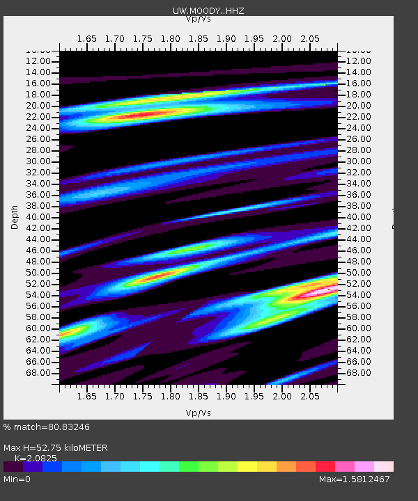
| Estimated Moho Depth: |
52.75 km |
| Estimated Crust Vp/Vs: |
2.08 |
| Assumed Crust Vp: |
6.134 km/s |
| Estimated Crust Vs: |
2.945 km/s |
| Estimated Crust Poisson's Ratio: |
0.35 |
|
| Radial Match: |
80.83246 % |
| Radial Bump: |
400 |
| Transverse Match: |
69.32625 % |
| Transverse Bump: |
400 |
| SOD ConfigId: |
31937991 |
| Insert Time: |
2023-11-28 06:10:26.834 +0000 |
| GWidth: |
2.5 |
| Max Bumps: |
400 |
| Tol: |
0.001 |
|

Signal To Noise
| Channel | StoN | STA | LTA |
| UW:MOODY: :HHZ:20231114T06:06:11.190023Z | 1.8387389 | 1.4703604E-6 | 7.99657E-7 |
| UW:MOODY: :HHN:20231114T06:06:11.190023Z | 0.77820784 | 4.5674486E-7 | 5.869189E-7 |
| UW:MOODY: :HHE:20231114T06:06:11.190023Z | 0.64340997 | 7.8877133E-7 | 1.2259235E-6 |
| Arrivals |
| Ps | 9.5 SECOND |
| PpPs | 26 SECOND |
| PsPs/PpSs | 36 SECOND |


