You are here: Home > Network List > IW - Intermountain West Stations List
> Station MOOW Moose Ponds, Wyoming, USA > Earthquake Result Viewer
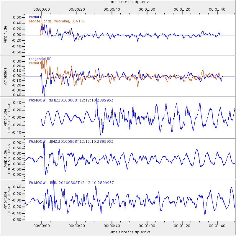
MOOW Moose Ponds, Wyoming, USA - Earthquake Result Viewer
*The percent match for this event was below the threshold and hence no stack was calculated.
| Earthquake location: |
Andreanof Islands, Aleutian Is. |
| Earthquake latitude/longitude: |
51.3/-178.6 |
| Earthquake time(UTC): |
2010/08/08 (220) 12:04:28 GMT |
| Earthquake Depth: |
29 km |
| Earthquake Magnitude: |
5.7 MB, 5.0 MS, 5.4 MW, 5.8 ML |
| Earthquake Catalog/Contributor: |
WHDF/NEIC |
|
| Network: |
IW Intermountain West |
| Station: |
MOOW Moose Ponds, Wyoming, USA |
| Lat/Lon: |
43.75 N/110.74 W |
| Elevation: |
2128 m |
|
| Distance: |
44.9 deg |
| Az: |
71.901 deg |
| Baz: |
304.61 deg |
| Ray Param: |
$rayparam |
*The percent match for this event was below the threshold and hence was not used in the summary stack. |
|
| Radial Match: |
43.096428 % |
| Radial Bump: |
400 |
| Transverse Match: |
75.34475 % |
| Transverse Bump: |
400 |
| SOD ConfigId: |
319893 |
| Insert Time: |
2011-01-05 18:30:45.357 +0000 |
| GWidth: |
2.5 |
| Max Bumps: |
400 |
| Tol: |
0.001 |
|
Signal To Noise
| Channel | StoN | STA | LTA |
| IW:MOOW: :BHZ:20100808T12:12:10.289995Z | 5.1846485 | 5.0522107E-7 | 9.7445586E-8 |
| IW:MOOW: :BHN:20100808T12:12:10.289995Z | 2.4209712 | 1.6064426E-7 | 6.63553E-8 |
| IW:MOOW: :BHE:20100808T12:12:10.289995Z | 2.217692 | 2.3878687E-7 | 1.07673586E-7 |
| Arrivals |
| Ps | |
| PpPs | |
| PsPs/PpSs | |


