You are here: Home > Network List > US - United States National Seismic Network Stations List
> Station MNTX Cornudas Mountains, Texas, USA > Earthquake Result Viewer
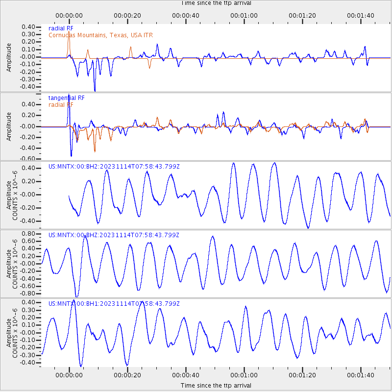
MNTX Cornudas Mountains, Texas, USA - Earthquake Result Viewer
*The percent match for this event was below the threshold and hence no stack was calculated.
| Earthquake location: |
South Of Kermadec Islands |
| Earthquake latitude/longitude: |
-32.6/-179.4 |
| Earthquake time(UTC): |
2023/11/14 (318) 07:46:02 GMT |
| Earthquake Depth: |
77 km |
| Earthquake Magnitude: |
5.4 Mww |
| Earthquake Catalog/Contributor: |
NEIC PDE/us |
|
| Network: |
US United States National Seismic Network |
| Station: |
MNTX Cornudas Mountains, Texas, USA |
| Lat/Lon: |
31.70 N/105.38 W |
| Elevation: |
405 m |
|
| Distance: |
94.7 deg |
| Az: |
55.317 deg |
| Baz: |
234.515 deg |
| Ray Param: |
$rayparam |
*The percent match for this event was below the threshold and hence was not used in the summary stack. |
|
| Radial Match: |
70.273155 % |
| Radial Bump: |
400 |
| Transverse Match: |
79.415375 % |
| Transverse Bump: |
400 |
| SOD ConfigId: |
31937991 |
| Insert Time: |
2023-11-28 08:01:12.808 +0000 |
| GWidth: |
2.5 |
| Max Bumps: |
400 |
| Tol: |
0.001 |
|
Signal To Noise
| Channel | StoN | STA | LTA |
| US:MNTX:00:BHZ:20231114T07:58:43.799Z | 2.5035336 | 5.1774526E-7 | 2.068058E-7 |
| US:MNTX:00:BH1:20231114T07:58:43.799Z | 1.4316717 | 3.0060386E-7 | 2.0996703E-7 |
| US:MNTX:00:BH2:20231114T07:58:43.799Z | 0.7725377 | 1.6215176E-7 | 2.0989495E-7 |
| Arrivals |
| Ps | |
| PpPs | |
| PsPs/PpSs | |


