You are here: Home > Network List > GS - US Geological Survey Networks Stations List
> Station KAN13 Rinehart Farm > Earthquake Result Viewer
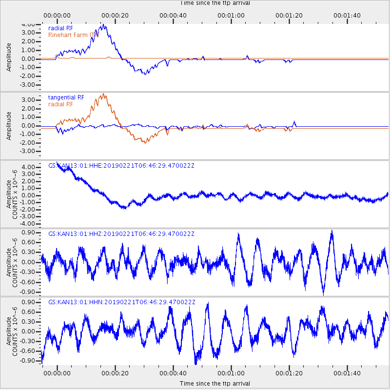
KAN13 Rinehart Farm - Earthquake Result Viewer
*The percent match for this event was below the threshold and hence no stack was calculated.
| Earthquake location: |
Fiji Islands Region |
| Earthquake latitude/longitude: |
-20.9/-178.8 |
| Earthquake time(UTC): |
2019/02/21 (052) 06:34:39 GMT |
| Earthquake Depth: |
617 km |
| Earthquake Magnitude: |
5.6 Mww |
| Earthquake Catalog/Contributor: |
NEIC PDE/us |
|
| Network: |
GS US Geological Survey Networks |
| Station: |
KAN13 Rinehart Farm |
| Lat/Lon: |
37.01 N/97.48 W |
| Elevation: |
340 m |
|
| Distance: |
95.7 deg |
| Az: |
52.682 deg |
| Baz: |
248.314 deg |
| Ray Param: |
$rayparam |
*The percent match for this event was below the threshold and hence was not used in the summary stack. |
|
| Radial Match: |
51.330235 % |
| Radial Bump: |
400 |
| Transverse Match: |
75.01573 % |
| Transverse Bump: |
400 |
| SOD ConfigId: |
3313551 |
| Insert Time: |
2019-03-07 06:41:50.966 +0000 |
| GWidth: |
2.5 |
| Max Bumps: |
400 |
| Tol: |
0.001 |
|
Signal To Noise
| Channel | StoN | STA | LTA |
| GS:KAN13:01:HHZ:20190221T06:46:29.470022Z | 0.48309296 | 1.8347838E-7 | 3.7979933E-7 |
| GS:KAN13:01:HHN:20190221T06:46:29.470022Z | 0.58670163 | 5.404365E-7 | 9.211436E-7 |
| GS:KAN13:01:HHE:20190221T06:46:29.470022Z | 0.85237664 | 1.6478403E-6 | 1.9332304E-6 |
| Arrivals |
| Ps | |
| PpPs | |
| PsPs/PpSs | |


