You are here: Home > Network List > GS - US Geological Survey Networks Stations List
> Station OK051 E0350 and S34600 Roads, Ralston, OK > Earthquake Result Viewer
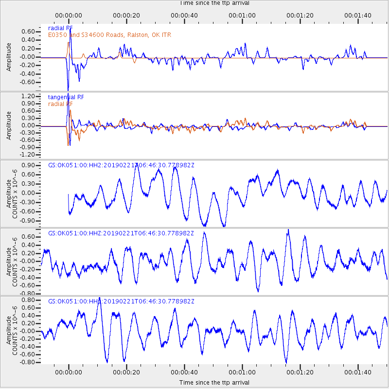
OK051 E0350 and S34600 Roads, Ralston, OK - Earthquake Result Viewer
*The percent match for this event was below the threshold and hence no stack was calculated.
| Earthquake location: |
Fiji Islands Region |
| Earthquake latitude/longitude: |
-20.9/-178.8 |
| Earthquake time(UTC): |
2019/02/21 (052) 06:34:39 GMT |
| Earthquake Depth: |
617 km |
| Earthquake Magnitude: |
5.6 Mww |
| Earthquake Catalog/Contributor: |
NEIC PDE/us |
|
| Network: |
GS US Geological Survey Networks |
| Station: |
OK051 E0350 and S34600 Roads, Ralston, OK |
| Lat/Lon: |
36.51 N/96.84 W |
| Elevation: |
263 m |
|
| Distance: |
96.0 deg |
| Az: |
53.346 deg |
| Baz: |
248.629 deg |
| Ray Param: |
$rayparam |
*The percent match for this event was below the threshold and hence was not used in the summary stack. |
|
| Radial Match: |
64.56783 % |
| Radial Bump: |
400 |
| Transverse Match: |
62.53026 % |
| Transverse Bump: |
400 |
| SOD ConfigId: |
3313551 |
| Insert Time: |
2019-03-07 06:41:59.858 +0000 |
| GWidth: |
2.5 |
| Max Bumps: |
400 |
| Tol: |
0.001 |
|
Signal To Noise
| Channel | StoN | STA | LTA |
| GS:OK051:00:HHZ:20190221T06:46:30.778982Z | 2.0037906 | 4.8565374E-7 | 2.4236752E-7 |
| GS:OK051:00:HH1:20190221T06:46:30.778982Z | 2.364599 | 7.026605E-7 | 2.971584E-7 |
| GS:OK051:00:HH2:20190221T06:46:30.778982Z | 1.5779972 | 5.8951184E-7 | 3.7358228E-7 |
| Arrivals |
| Ps | |
| PpPs | |
| PsPs/PpSs | |


