You are here: Home > Network List > AT - Alaska Tsunami Warning Seismic System Stations List
> Station ESTR Esther Passage, Barry Arm, Alaska > Earthquake Result Viewer
ESTR Esther Passage, Barry Arm, Alaska - Earthquake Result Viewer
| Earthquake location: |
Minahassa Peninsula, Sulawesi |
| Earthquake latitude/longitude: |
2.0/124.1 |
| Earthquake time(UTC): |
2023/11/15 (319) 23:26:15 GMT |
| Earthquake Depth: |
303 km |
| Earthquake Magnitude: |
5.7 Mww |
| Earthquake Catalog/Contributor: |
NEIC PDE/us |
|
| Network: |
AT Alaska Tsunami Warning Seismic System |
| Station: |
ESTR Esther Passage, Barry Arm, Alaska |
| Lat/Lon: |
60.95 N/148.05 W |
| Elevation: |
3.9 m |
|
| Distance: |
87.2 deg |
| Az: |
29.233 deg |
| Baz: |
269.047 deg |
| Ray Param: |
0.04273523 |
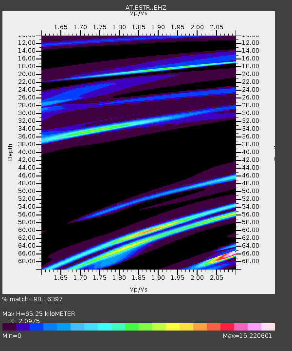
| Estimated Moho Depth: |
65.25 km |
| Estimated Crust Vp/Vs: |
2.10 |
| Assumed Crust Vp: |
6.566 km/s |
| Estimated Crust Vs: |
3.13 km/s |
| Estimated Crust Poisson's Ratio: |
0.35 |
|
| Radial Match: |
98.16397 % |
| Radial Bump: |
69 |
| Transverse Match: |
99.11527 % |
| Transverse Bump: |
48 |
| SOD ConfigId: |
31937991 |
| Insert Time: |
2023-11-29 23:29:48.673 +0000 |
| GWidth: |
2.5 |
| Max Bumps: |
400 |
| Tol: |
0.001 |
|

Signal To Noise
| Channel | StoN | STA | LTA |
| AT:ESTR: :BHZ:20231115T23:37:57.01998Z | 1.3315165 | 1.2305946E-5 | 9.242053E-6 |
| AT:ESTR: :BHN:20231115T23:37:57.01998Z | 1.292964 | 4.4759072E-4 | 3.4617417E-4 |
| AT:ESTR: :BHE:20231115T23:37:57.01998Z | 1.2689891 | 0.0014233498 | 0.0011216407 |
| Arrivals |
| Ps | 11 SECOND |
| PpPs | 30 SECOND |
| PsPs/PpSs | 41 SECOND |


