You are here: Home > Network List > AV - Alaska Volcano Observatory Stations List
> Station MAPS Pakushin Southeast, Makushin Volcano, Alaska > Earthquake Result Viewer
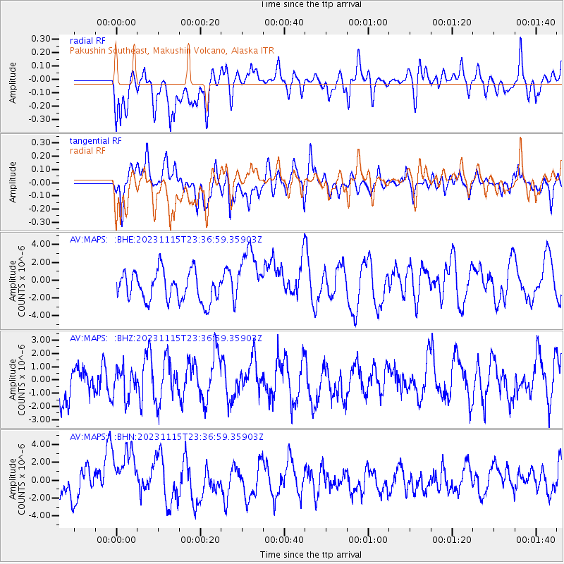
MAPS Pakushin Southeast, Makushin Volcano, Alaska - Earthquake Result Viewer
*The percent match for this event was below the threshold and hence no stack was calculated.
| Earthquake location: |
Minahassa Peninsula, Sulawesi |
| Earthquake latitude/longitude: |
2.0/124.1 |
| Earthquake time(UTC): |
2023/11/15 (319) 23:26:15 GMT |
| Earthquake Depth: |
303 km |
| Earthquake Magnitude: |
5.7 Mww |
| Earthquake Catalog/Contributor: |
NEIC PDE/us |
|
| Network: |
AV Alaska Volcano Observatory |
| Station: |
MAPS Pakushin Southeast, Makushin Volcano, Alaska |
| Lat/Lon: |
53.81 N/166.94 W |
| Elevation: |
333 m |
|
| Distance: |
76.1 deg |
| Az: |
34.761 deg |
| Baz: |
253.905 deg |
| Ray Param: |
$rayparam |
*The percent match for this event was below the threshold and hence was not used in the summary stack. |
|
| Radial Match: |
52.130135 % |
| Radial Bump: |
400 |
| Transverse Match: |
43.345856 % |
| Transverse Bump: |
400 |
| SOD ConfigId: |
31937991 |
| Insert Time: |
2023-11-29 23:31:26.578 +0000 |
| GWidth: |
2.5 |
| Max Bumps: |
400 |
| Tol: |
0.001 |
|
Signal To Noise
| Channel | StoN | STA | LTA |
| AV:MAPS: :BHZ:20231115T23:36:59.35903Z | 0.5484947 | 1.1090871E-6 | 2.0220562E-6 |
| AV:MAPS: :BHN:20231115T23:36:59.35903Z | 2.361222 | 3.5149753E-6 | 1.4886256E-6 |
| AV:MAPS: :BHE:20231115T23:36:59.35903Z | 1.932051 | 3.1944276E-6 | 1.6533869E-6 |
| Arrivals |
| Ps | |
| PpPs | |
| PsPs/PpSs | |


