You are here: Home > Network List > TA - USArray Transportable Network (new EarthScope stations) Stations List
> Station W28A Vega, TX, USA > Earthquake Result Viewer
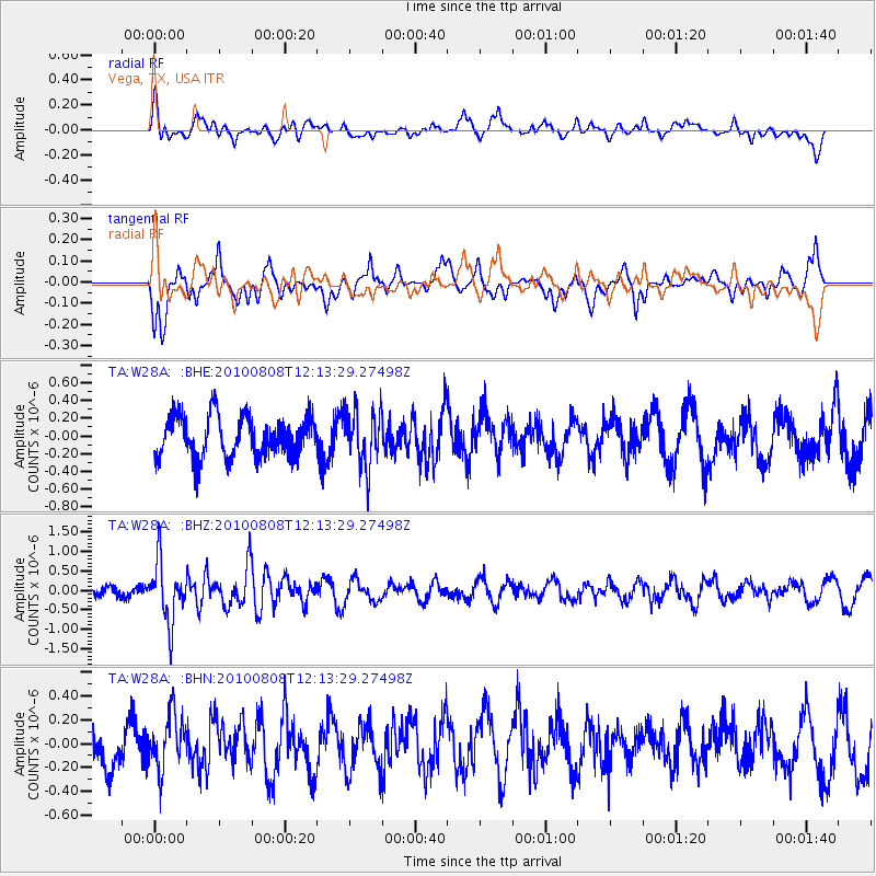
W28A Vega, TX, USA - Earthquake Result Viewer
*The percent match for this event was below the threshold and hence no stack was calculated.
| Earthquake location: |
Andreanof Islands, Aleutian Is. |
| Earthquake latitude/longitude: |
51.3/-178.6 |
| Earthquake time(UTC): |
2010/08/08 (220) 12:04:28 GMT |
| Earthquake Depth: |
29 km |
| Earthquake Magnitude: |
5.7 MB, 5.0 MS, 5.4 MW, 5.8 ML |
| Earthquake Catalog/Contributor: |
WHDF/NEIC |
|
| Network: |
TA USArray Transportable Network (new EarthScope stations) |
| Station: |
W28A Vega, TX, USA |
| Lat/Lon: |
35.26 N/102.21 W |
| Elevation: |
1156 m |
|
| Distance: |
55.3 deg |
| Az: |
75.191 deg |
| Baz: |
312.159 deg |
| Ray Param: |
$rayparam |
*The percent match for this event was below the threshold and hence was not used in the summary stack. |
|
| Radial Match: |
50.610954 % |
| Radial Bump: |
400 |
| Transverse Match: |
68.34979 % |
| Transverse Bump: |
400 |
| SOD ConfigId: |
319893 |
| Insert Time: |
2011-01-05 18:40:40.668 +0000 |
| GWidth: |
2.5 |
| Max Bumps: |
400 |
| Tol: |
0.001 |
|
Signal To Noise
| Channel | StoN | STA | LTA |
| TA:W28A: :BHZ:20100808T12:13:29.27498Z | 4.2112985 | 7.719587E-7 | 1.8330657E-7 |
| TA:W28A: :BHN:20100808T12:13:29.27498Z | 1.1506369 | 2.2839745E-7 | 1.9849654E-7 |
| TA:W28A: :BHE:20100808T12:13:29.27498Z | 1.3793573 | 3.1684115E-7 | 2.2970202E-7 |
| Arrivals |
| Ps | |
| PpPs | |
| PsPs/PpSs | |


