You are here: Home > Network List > IU - Global Seismograph Network (GSN - IRIS/USGS) Stations List
> Station PMG Port Moresby, New Guinea > Earthquake Result Viewer
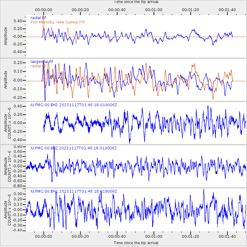
PMG Port Moresby, New Guinea - Earthquake Result Viewer
*The percent match for this event was below the threshold and hence no stack was calculated.
| Earthquake location: |
Myanmar-China Border Region |
| Earthquake latitude/longitude: |
21.2/99.3 |
| Earthquake time(UTC): |
2023/11/17 (321) 01:37:10 GMT |
| Earthquake Depth: |
10 km |
| Earthquake Magnitude: |
5.7 mww |
| Earthquake Catalog/Contributor: |
NEIC PDE/us |
|
| Network: |
IU Global Seismograph Network (GSN - IRIS/USGS) |
| Station: |
PMG Port Moresby, New Guinea |
| Lat/Lon: |
9.40 S/147.16 E |
| Elevation: |
90 m |
|
| Distance: |
56.0 deg |
| Az: |
118.066 deg |
| Baz: |
303.454 deg |
| Ray Param: |
$rayparam |
*The percent match for this event was below the threshold and hence was not used in the summary stack. |
|
| Radial Match: |
58.96538 % |
| Radial Bump: |
400 |
| Transverse Match: |
54.63152 % |
| Transverse Bump: |
400 |
| SOD ConfigId: |
31937991 |
| Insert Time: |
2023-12-01 01:47:14.099 +0000 |
| GWidth: |
2.5 |
| Max Bumps: |
400 |
| Tol: |
0.001 |
|
Signal To Noise
| Channel | StoN | STA | LTA |
| IU:PMG:00:BHZ:20231117T01:46:18.019006Z | 2.2815645 | 2.4341173E-7 | 1.0668633E-7 |
| IU:PMG:00:BH1:20231117T01:46:18.019006Z | 1.4235442 | 1.3050894E-7 | 9.167888E-8 |
| IU:PMG:00:BH2:20231117T01:46:18.019006Z | 0.7170243 | 7.9556685E-8 | 1.1095395E-7 |
| Arrivals |
| Ps | |
| PpPs | |
| PsPs/PpSs | |


