You are here: Home > Network List > AK - Alaska Regional Network Stations List
> Station BAT Barry Arm Top, AK, USA > Earthquake Result Viewer
BAT Barry Arm Top, AK, USA - Earthquake Result Viewer
| Earthquake location: |
Mindanao, Philippines |
| Earthquake latitude/longitude: |
5.6/125.0 |
| Earthquake time(UTC): |
2023/11/17 (321) 08:14:11 GMT |
| Earthquake Depth: |
64 km |
| Earthquake Magnitude: |
6.7 Mww |
| Earthquake Catalog/Contributor: |
NEIC PDE/us |
|
| Network: |
AK Alaska Regional Network |
| Station: |
BAT Barry Arm Top, AK, USA |
| Lat/Lon: |
61.14 N/148.18 W |
| Elevation: |
1027 m |
|
| Distance: |
83.6 deg |
| Az: |
29.171 deg |
| Baz: |
269.905 deg |
| Ray Param: |
0.045950584 |
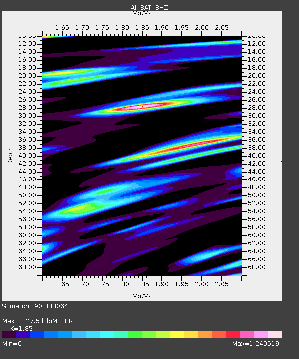
| Estimated Moho Depth: |
27.5 km |
| Estimated Crust Vp/Vs: |
1.85 |
| Assumed Crust Vp: |
6.566 km/s |
| Estimated Crust Vs: |
3.549 km/s |
| Estimated Crust Poisson's Ratio: |
0.29 |
|
| Radial Match: |
90.883064 % |
| Radial Bump: |
400 |
| Transverse Match: |
89.86792 % |
| Transverse Bump: |
400 |
| SOD ConfigId: |
31937991 |
| Insert Time: |
2023-12-01 08:16:22.886 +0000 |
| GWidth: |
2.5 |
| Max Bumps: |
400 |
| Tol: |
0.001 |
|

Signal To Noise
| Channel | StoN | STA | LTA |
| AK:BAT: :BHZ:20231117T08:26:02.09998Z | 56.87908 | 1.0790524E-5 | 1.897099E-7 |
| AK:BAT: :BHN:20231117T08:26:02.09998Z | 6.252081 | 1.475011E-6 | 2.3592321E-7 |
| AK:BAT: :BHE:20231117T08:26:02.09998Z | 34.72757 | 5.5771698E-6 | 1.6059776E-7 |
| Arrivals |
| Ps | 3.7 SECOND |
| PpPs | 12 SECOND |
| PsPs/PpSs | 15 SECOND |


