You are here: Home > Network List > TA - USArray Transportable Network (new EarthScope stations) Stations List
> Station U28A Mallet, Rita Blanca National Grassland, TX, USA > Earthquake Result Viewer
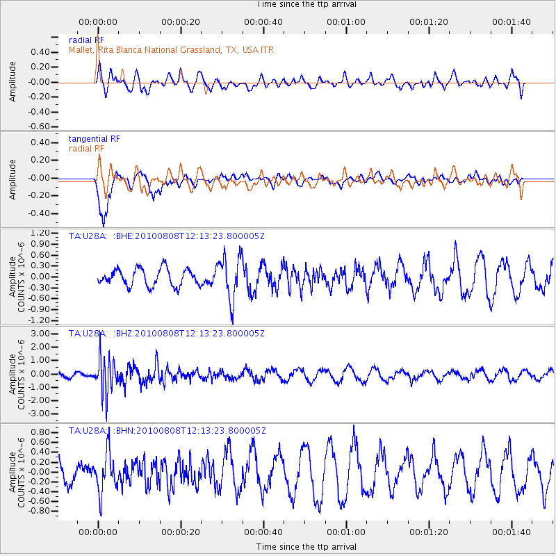
U28A Mallet, Rita Blanca National Grassland, TX, USA - Earthquake Result Viewer
*The percent match for this event was below the threshold and hence no stack was calculated.
| Earthquake location: |
Andreanof Islands, Aleutian Is. |
| Earthquake latitude/longitude: |
51.3/-178.6 |
| Earthquake time(UTC): |
2010/08/08 (220) 12:04:28 GMT |
| Earthquake Depth: |
29 km |
| Earthquake Magnitude: |
5.7 MB, 5.0 MS, 5.4 MW, 5.8 ML |
| Earthquake Catalog/Contributor: |
WHDF/NEIC |
|
| Network: |
TA USArray Transportable Network (new EarthScope stations) |
| Station: |
U28A Mallet, Rita Blanca National Grassland, TX, USA |
| Lat/Lon: |
36.38 N/102.22 W |
| Elevation: |
1165 m |
|
| Distance: |
54.6 deg |
| Az: |
74.185 deg |
| Baz: |
311.571 deg |
| Ray Param: |
$rayparam |
*The percent match for this event was below the threshold and hence was not used in the summary stack. |
|
| Radial Match: |
52.765396 % |
| Radial Bump: |
400 |
| Transverse Match: |
85.66997 % |
| Transverse Bump: |
349 |
| SOD ConfigId: |
319893 |
| Insert Time: |
2011-01-05 18:45:38.359 +0000 |
| GWidth: |
2.5 |
| Max Bumps: |
400 |
| Tol: |
0.001 |
|
Signal To Noise
| Channel | StoN | STA | LTA |
| TA:U28A: :BHZ:20100808T12:13:23.800005Z | 8.645459 | 1.3078434E-6 | 1.5127517E-7 |
| TA:U28A: :BHN:20100808T12:13:23.800005Z | 2.4890883 | 4.118114E-7 | 1.6544669E-7 |
| TA:U28A: :BHE:20100808T12:13:23.800005Z | 2.6203172 | 6.112966E-7 | 2.3329108E-7 |
| Arrivals |
| Ps | |
| PpPs | |
| PsPs/PpSs | |


