You are here: Home > Network List > TA - USArray Transportable Network (new EarthScope stations) Stations List
> Station P30A Selden, KS, USA > Earthquake Result Viewer
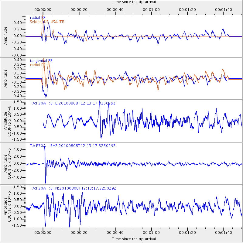
P30A Selden, KS, USA - Earthquake Result Viewer
*The percent match for this event was below the threshold and hence no stack was calculated.
| Earthquake location: |
Andreanof Islands, Aleutian Is. |
| Earthquake latitude/longitude: |
51.3/-178.6 |
| Earthquake time(UTC): |
2010/08/08 (220) 12:04:28 GMT |
| Earthquake Depth: |
29 km |
| Earthquake Magnitude: |
5.7 MB, 5.0 MS, 5.4 MW, 5.8 ML |
| Earthquake Catalog/Contributor: |
WHDF/NEIC |
|
| Network: |
TA USArray Transportable Network (new EarthScope stations) |
| Station: |
P30A Selden, KS, USA |
| Lat/Lon: |
39.54 N/100.25 W |
| Elevation: |
788 m |
|
| Distance: |
53.7 deg |
| Az: |
69.976 deg |
| Baz: |
310.317 deg |
| Ray Param: |
$rayparam |
*The percent match for this event was below the threshold and hence was not used in the summary stack. |
|
| Radial Match: |
75.087296 % |
| Radial Bump: |
400 |
| Transverse Match: |
70.3894 % |
| Transverse Bump: |
400 |
| SOD ConfigId: |
319893 |
| Insert Time: |
2011-01-05 18:46:25.387 +0000 |
| GWidth: |
2.5 |
| Max Bumps: |
400 |
| Tol: |
0.001 |
|
Signal To Noise
| Channel | StoN | STA | LTA |
| TA:P30A: :BHZ:20100808T12:13:17.325029Z | 7.9310813 | 2.0335358E-6 | 2.5640082E-7 |
| TA:P30A: :BHN:20100808T12:13:17.325029Z | 2.508352 | 6.4257966E-7 | 2.5617604E-7 |
| TA:P30A: :BHE:20100808T12:13:17.325029Z | 2.3711736 | 7.2926247E-7 | 3.075534E-7 |
| Arrivals |
| Ps | |
| PpPs | |
| PsPs/PpSs | |


