You are here: Home > Network List > AV - Alaska Volcano Observatory Stations List
> Station PLBL Mt. Peulik Volcano, Alaska > Earthquake Result Viewer
PLBL Mt. Peulik Volcano, Alaska - Earthquake Result Viewer
| Earthquake location: |
Mindanao, Philippines |
| Earthquake latitude/longitude: |
5.6/125.0 |
| Earthquake time(UTC): |
2023/11/17 (321) 08:14:11 GMT |
| Earthquake Depth: |
64 km |
| Earthquake Magnitude: |
6.7 Mww |
| Earthquake Catalog/Contributor: |
NEIC PDE/us |
|
| Network: |
AV Alaska Volcano Observatory |
| Station: |
PLBL Mt. Peulik Volcano, Alaska |
| Lat/Lon: |
57.70 N/156.82 W |
| Elevation: |
461 m |
|
| Distance: |
79.0 deg |
| Az: |
32.37 deg |
| Baz: |
262.952 deg |
| Ray Param: |
0.0491541 |
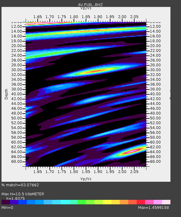
| Estimated Moho Depth: |
10.5 km |
| Estimated Crust Vp/Vs: |
1.64 |
| Assumed Crust Vp: |
6.1 km/s |
| Estimated Crust Vs: |
3.725 km/s |
| Estimated Crust Poisson's Ratio: |
0.20 |
|
| Radial Match: |
83.07662 % |
| Radial Bump: |
400 |
| Transverse Match: |
74.28967 % |
| Transverse Bump: |
400 |
| SOD ConfigId: |
31937991 |
| Insert Time: |
2023-12-01 08:23:37.813 +0000 |
| GWidth: |
2.5 |
| Max Bumps: |
400 |
| Tol: |
0.001 |
|
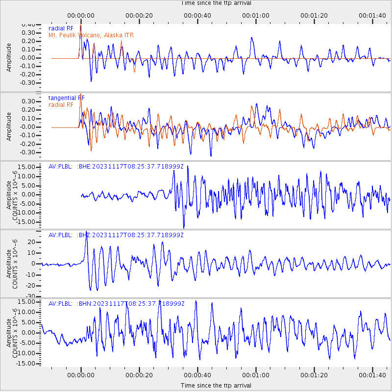
Signal To Noise
| Channel | StoN | STA | LTA |
| AV:PLBL: :BHZ:20231117T08:25:37.718999Z | 16.276236 | 1.3430311E-5 | 8.251485E-7 |
| AV:PLBL: :BHN:20231117T08:25:37.718999Z | 1.5121815 | 3.4604443E-6 | 2.288379E-6 |
| AV:PLBL: :BHE:20231117T08:25:37.718999Z | 4.505375 | 5.5346363E-6 | 1.2284519E-6 |
| Arrivals |
| Ps | 1.1 SECOND |
| PpPs | 4.4 SECOND |
| PsPs/PpSs | 5.5 SECOND |


