You are here: Home > Network List > AV - Alaska Volcano Observatory Stations List
> Station R17L Mt. Peulik Volcano, AVO PLK4, AK, USA > Earthquake Result Viewer
R17L Mt. Peulik Volcano, AVO PLK4, AK, USA - Earthquake Result Viewer
| Earthquake location: |
Mindanao, Philippines |
| Earthquake latitude/longitude: |
5.6/125.0 |
| Earthquake time(UTC): |
2023/11/17 (321) 08:14:11 GMT |
| Earthquake Depth: |
64 km |
| Earthquake Magnitude: |
6.7 Mww |
| Earthquake Catalog/Contributor: |
NEIC PDE/us |
|
| Network: |
AV Alaska Volcano Observatory |
| Station: |
R17L Mt. Peulik Volcano, AVO PLK4, AK, USA |
| Lat/Lon: |
57.63 N/156.36 W |
| Elevation: |
524 m |
|
| Distance: |
79.2 deg |
| Az: |
32.469 deg |
| Baz: |
263.36 deg |
| Ray Param: |
0.048991654 |
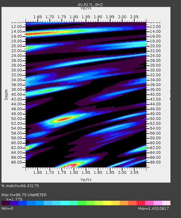
| Estimated Moho Depth: |
69.75 km |
| Estimated Crust Vp/Vs: |
1.77 |
| Assumed Crust Vp: |
6.1 km/s |
| Estimated Crust Vs: |
3.437 km/s |
| Estimated Crust Poisson's Ratio: |
0.27 |
|
| Radial Match: |
86.43175 % |
| Radial Bump: |
400 |
| Transverse Match: |
80.4931 % |
| Transverse Bump: |
400 |
| SOD ConfigId: |
31937991 |
| Insert Time: |
2023-12-01 08:23:51.426 +0000 |
| GWidth: |
2.5 |
| Max Bumps: |
400 |
| Tol: |
0.001 |
|

Signal To Noise
| Channel | StoN | STA | LTA |
| AV:R17L: :BHZ:20231117T08:25:39.000005Z | 22.340635 | 1.1745796E-5 | 5.257592E-7 |
| AV:R17L: :BHN:20231117T08:25:39.000005Z | 2.7515855 | 1.4250752E-6 | 5.1791056E-7 |
| AV:R17L: :BHE:20231117T08:25:39.000005Z | 6.5920115 | 3.7209961E-6 | 5.6447055E-7 |
| Arrivals |
| Ps | 9.1 SECOND |
| PpPs | 31 SECOND |
| PsPs/PpSs | 40 SECOND |


