You are here: Home > Network List > AV - Alaska Volcano Observatory Stations List
> Station SPNN North Nagishlamina, Mount Spurr, Alaska > Earthquake Result Viewer
SPNN North Nagishlamina, Mount Spurr, Alaska - Earthquake Result Viewer
| Earthquake location: |
Mindanao, Philippines |
| Earthquake latitude/longitude: |
5.6/125.0 |
| Earthquake time(UTC): |
2023/11/17 (321) 08:14:11 GMT |
| Earthquake Depth: |
64 km |
| Earthquake Magnitude: |
6.7 Mww |
| Earthquake Catalog/Contributor: |
NEIC PDE/us |
|
| Network: |
AV Alaska Volcano Observatory |
| Station: |
SPNN North Nagishlamina, Mount Spurr, Alaska |
| Lat/Lon: |
61.37 N/152.70 W |
| Elevation: |
1666 m |
|
| Distance: |
81.4 deg |
| Az: |
28.863 deg |
| Baz: |
265.902 deg |
| Ray Param: |
0.04747628 |
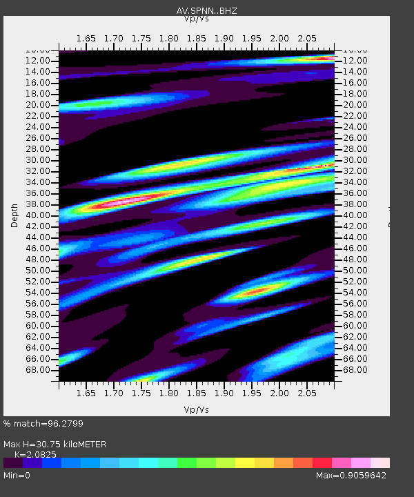
| Estimated Moho Depth: |
30.75 km |
| Estimated Crust Vp/Vs: |
2.08 |
| Assumed Crust Vp: |
6.566 km/s |
| Estimated Crust Vs: |
3.153 km/s |
| Estimated Crust Poisson's Ratio: |
0.35 |
|
| Radial Match: |
96.2799 % |
| Radial Bump: |
400 |
| Transverse Match: |
92.77616 % |
| Transverse Bump: |
400 |
| SOD ConfigId: |
31937991 |
| Insert Time: |
2023-12-01 08:24:09.144 +0000 |
| GWidth: |
2.5 |
| Max Bumps: |
400 |
| Tol: |
0.001 |
|

Signal To Noise
| Channel | StoN | STA | LTA |
| AV:SPNN: :BHZ:20231117T08:25:50.818975Z | 61.918495 | 1.7013965E-5 | 2.7478E-7 |
| AV:SPNN: :BHN:20231117T08:25:50.818975Z | 5.6991353 | 1.5984716E-6 | 2.8047614E-7 |
| AV:SPNN: :BHE:20231117T08:25:50.818975Z | 36.430065 | 6.6719763E-6 | 1.8314478E-7 |
| Arrivals |
| Ps | 5.2 SECOND |
| PpPs | 14 SECOND |
| PsPs/PpSs | 19 SECOND |


