You are here: Home > Network List > G - GEOSCOPE Stations List
> Station CAN Canberra, Australia > Earthquake Result Viewer
CAN Canberra, Australia - Earthquake Result Viewer
| Earthquake location: |
Mindanao, Philippines |
| Earthquake latitude/longitude: |
5.6/125.0 |
| Earthquake time(UTC): |
2023/11/17 (321) 08:14:11 GMT |
| Earthquake Depth: |
64 km |
| Earthquake Magnitude: |
6.7 Mww |
| Earthquake Catalog/Contributor: |
NEIC PDE/us |
|
| Network: |
G GEOSCOPE |
| Station: |
CAN Canberra, Australia |
| Lat/Lon: |
35.32 S/149.00 E |
| Elevation: |
650 m |
|
| Distance: |
46.5 deg |
| Az: |
152.745 deg |
| Baz: |
326.125 deg |
| Ray Param: |
0.07040918 |
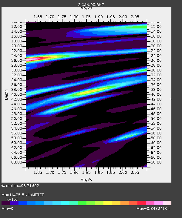
| Estimated Moho Depth: |
25.5 km |
| Estimated Crust Vp/Vs: |
1.60 |
| Assumed Crust Vp: |
6.633 km/s |
| Estimated Crust Vs: |
4.146 km/s |
| Estimated Crust Poisson's Ratio: |
0.18 |
|
| Radial Match: |
96.71692 % |
| Radial Bump: |
313 |
| Transverse Match: |
89.14535 % |
| Transverse Bump: |
400 |
| SOD ConfigId: |
31937991 |
| Insert Time: |
2023-12-01 08:26:20.250 +0000 |
| GWidth: |
2.5 |
| Max Bumps: |
400 |
| Tol: |
0.001 |
|
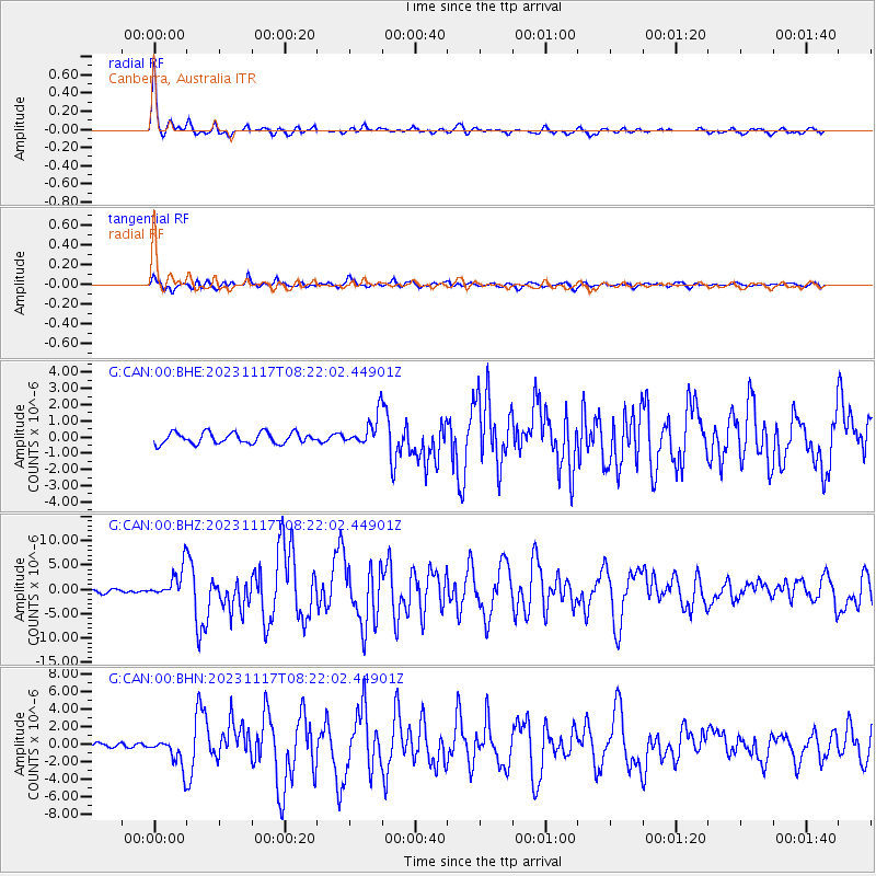
Signal To Noise
| Channel | StoN | STA | LTA |
| G:CAN:00:BHZ:20231117T08:22:02.44901Z | 7.2480726 | 3.2269731E-6 | 4.4521812E-7 |
| G:CAN:00:BHN:20231117T08:22:02.44901Z | 6.580113 | 1.6961804E-6 | 2.5777376E-7 |
| G:CAN:00:BHE:20231117T08:22:02.44901Z | 2.7779908 | 9.454687E-7 | 3.4034264E-7 |
| Arrivals |
| Ps | 2.5 SECOND |
| PpPs | 9.3 SECOND |
| PsPs/PpSs | 12 SECOND |


